Home
Shopping cart (0 items € 0)
Advanced search

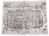
With attractive maps of the Holy Land

ADRICHEM, Christiaan van. Theatrum Terrae Sanctae et biblicarum historiarum cum tabulis geographicis aere expressis.
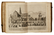
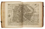
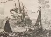
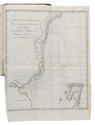
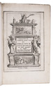
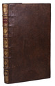
[Cologne, Officina Birckmannica, for Hermann Mylius, 1628]. Folio. With engraved allegorical title-page, numerous decorated woodcut initial letters and tailpieces, 11 maps of Israel and 1 map of Jerusalem (8 folding and 4 double-page). Contemporary calf, gold-tooled spine with red morocco title-label, blind-tooled sides, gilt binding edges. [12], 286, [30] pp. Full description
€ 10,000
Order Inquire Terms of sale

Ethnography of the Xhosa people of South Africa, with the very rare album with four attractive hand-coloured aquatints

ALBERTI, Lodewyk and Ludwig Gottlieb PORTMAN. [Drop-title:] Zuid-Afrikaansche gezichten.
Amsterdam, Evert Maaskamp, [1810]. Oblong 1mo (45 x 60 cm). Letterpress text leaf and 4 large aquatint plates coloured by a contemporary hand, engraved by Ludwig Gottlieb Portman after drawings by Jacob Smies and Christopher Howen. Contemporary stiff, marbled paper wrappers, kept in a modern green half morocco clamshell box.
With:
(2) ALBERTI, Lodewyk. De Kaffers aan de zuidkust van Afrika, natuur en geschiedkundig beschreven.
Amsterdam, Evert Maaskamp, 1810. 8vo. With engraved title-page, aquatint folding plan, with coastal view, of Algoa Bay, and 2 stipple-engraved plates, all but the title-page coloured by a contemporary hand. Contemporary gold-tooled calf; rebacked, with new endpapers.
(3) ALBERTI, Lodewyk. Description physique et historique des Cafres, sur la côte méridionale de l'Afrique ...
Amsterdam, Evert Maaskamp, 1811. 8vo. With the same plan and 2 plates as ad. 2, also coloured by a contemporary hand. Contemporary gold-tooled calf, richly gold-tooled spine. [1] l. text + 4 plates; [8], VIII, [4], 260, [1], [1 blank] pp.; XII, [4], 255, [1 blank] pp. Full description
€ 25,000
Order Inquire Terms of sale

“to this day a major source of information about the land and peoples of Paraguay and Río de la Plata”

AZARA, Félix Manuel de. Voyages dans l'Amérique Méridionale, ... depuis 1781 jusqu'en 1801; contenant la description géographique, politique et civile du Paraguay et de la rivière de La Plata; ...
Paris, Dentu, 1809. 8vo (4 text volumes) and folio (1 atlas volume). With 3 folding tables and 25 engraved maps, plans, views and plates of animals and birds. Modern black half calf, gold-tooled spine. LX, 389; [4], 388-562; [4], II, 479; [4], 380 pp. Full description
€ 12,500
Order Inquire Terms of sale

First edition of a richly illustrated account of Surinam

BENOIT, Pierre Jacques. Voyage a Surinam. Description des possessions néerlandaises dans la Guyane.
Brussels, De Wasme & Laurent (back of half-title: Imprimerie de Societé des Beaux-Arts), 1839. Folio (47.5 x 31 cm). With a lithographed frontispiece, a small wood-engraved illustration on the title-page, and 99 tinted lithographed illustrations on 49 plates. Contemporary half black morocco, black cloth sides, gold-tooled spine. [4], 1-69, [3], 75-76, [2] pp. Full description
€ 2,750
Order Inquire Terms of sale

Rare and extensive work on Algeria, spectacularly illustrated with 133 large plates, some in colour

BERBRUGGER, Louis Adrien. Algerie historique, pittoresque et monumentale, ou Recueil de vues, costumes et portraits faits d'après nature dans les provinces d'Alger, Bone, Constantine et Oran.
Paris, Delahaye (part-titles: printed by Dondey-Dupré), 1843. 5 parts in 3 volumes. Royal 1mo (57 x 42.5 cm). With chromo-lithographed general title-page, tinted lithographed frontispiece, 2 lithographed maps hand-coloured in outline, and 133 lithographed plates (image size up to 44.5 x 30.5 cm, nearly all non-botanical ones tinted and one with 2 chromolithographed and hand-coloured costume prints) by and after artists including Charles Bour, Eugène Flandin, Félix Emmanuel Henri Philippoteaux and Denis Auguste Marie Raffet. Also with lithographed views (and a few lithographed maps) printed in the tail margins at the ends of many chapters, and 45 white-on-black wood-engravings of coins (each with obverse and reverse) in the text. The 72 botanical illustrations on the last 10 lithographed plates are coloured by hand and highlighted with gum arabic. The non-botanical plates have the publisher's embossed stamp in the foot margin. Contemporary, uniform dark green half goatskin morocco with a gold-tooled spine. XIV, [3], [1 blank], 80; [3], [1 blank], 68; [3], [1 blank], 42; [3], [1 blank], 21, [1 blank], 18, 16, [1], [1 blank] pp. including the chromolithographed title-page. Full description
€ 28,500
Order Inquire Terms of sale

Large view of ships and boats in the IJ inlet, with Amsterdam in the background, with Tsar Peter the Great of Russia viewing the ship he helped build

BERGE, Pieter van den. Amstelaedamum omnium recentissimè et accuratissime expressum à Petro van den Berghe, Moschus, Arabs[,] Persae, Maurus, Judaeus, uterque[.] Quod ferat huc, rursusque auferat, Indus habet. Hanc dum mundus adit mundumque haec ipsa perrat[!], non urbs fixa loco, sed vagus orbis erit.
Amsterdam, Gerard van Keulen, [ca. 1720]. Etched view (50.5 x 81 cm) on two sheets. In a modern wooden frame. Full description
€ 15,000
Order Inquire Terms of sale

Large paper copy of the first Dutch edition of Blaeu's great atlas of cities and towns of the Dutch Republic, with 320 mostly double-page maps, plans and views

BLAEU, Joan. [Toonneel der steden van de Vereenighde Nederlanden, met hare beschrijvingen, ...].
With: [Toonneel der steden van s Konings Nederlanden, met hare beschrijvingen, ...].
[Amsterdam, Joan Blaeu, 1652]. 2 volumes. Atlas folio (57 × 37 cm). With two engraved architectural title-pages, each with a blank central panel where a letterpress slip with the title and the publishers name would have been pasted; 181 (Dutch Republic) & 139 (Spanish Netherlands) maps, plans and views plus 2 smaller engravings in text; 20 woodcut illustration figures in the text. Uniform, early 18th-century(?) half red sheepskin. Full description
€ 68,500
Order Inquire Terms of sale

Rare description of Mozambique in the 19th-century, written by a former captain general of the colony

BOTELHO, Sebastião Xavier. Memoria estatistica sobre os dominios Portuguezes na Africa oriental.
Lisbon, José Baptista Morando, 1835. 8vo. With six folding lithographic plates in the back, including maps of the Maputo, Inhambane, Quelimane and Mocambo bays, as well as a plan of its capital Maputo and a view of the residence of the Portuguese "capitão generales" (Captain-General) of Mozambique, a position which Botelho himself had held. Contemporary calf. [1], [1 blank], 400, [1], [1 blank], [1], [1 blank] pp. Full description
€ 2,500
Order Inquire Terms of sale

17th-century Hungary, Dalmatia, and the Peloponnese depicted in numerous engraved plates

BOUTTATS, Gaspar (engraver). Korte en nette beschryvinghe van de koninckrycken Hongheryen en Dalmatien, Midts-gaeders de vorstendommen van Sevenberghen, Wallachien, Moldavien, Burgarien, etc. ...
Antwerpen, Hendrick van Dunewalt and Gasper Bouttats, 1688.
With: (2) [BOUTATTS Gaspar (compiler) and Vincenzo Maria CORONELLI (engraver)]. Korte, beknoopte, en nette beschryvinghe van het koninck-ryck Morea. ...
Antwerpen, Hendrick van Dunwalt and Gaspar Bouttats, [ca. 1685?].
Oblong 8vo (ca. 12 x 19 cm). With 82 full-page engraved plates (44 in ad 1 and 38 (including 1 folding) in ad 2). Contemporary gold-tooled calf (or sheepskin), sewn on 3 supports with the corresponding raised bands on the spine. 47, [1 blank] and 44 engraved plates; [1], [1 blank], 24 pp. and 38 engraved plates. Full description
€ 7,500
Order Inquire Terms of sale
99 books found / Show all