Home
Shopping cart (0 items € 0)
Advanced search

Presentation copy of an authoritative handbook on the Arab states of the Lower Gulf
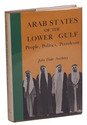
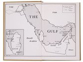
ANTHONY, John Duke. Arab states of the Lower Gulf: People, Politics, Petroleum.
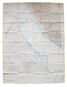
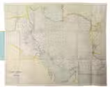
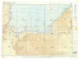
Washington D.C., The Middle East institute, 1975. 8vo. With two black and white maps on the endpapers. Brown cloth with publisher's illustrated dust jacket. X, 273, [1 blank] pp. Full description
€ 500
Order Inquire Terms of sale

First printed record of Abu Dhabi and Dubai: the first Latin edition

DE BRY, Theodor; Johann Israel DE BRY and Joris VAN SPILBERGEN. Indiae Orientalis pars septima [...].Including: Icones, hoc est verae variorum populorum et regum, ceremoniarum item, superstitiosorum rituum et rerum aliarum, ...
Frankfurt, Wolfgang Richter, 1606. Folio (32.5 x 20 cm). With the letterpress title in an engraved architectural border, a separate letterpress title-page for the Icones, an engraved coat of arms on the dedication leaf, 20 engravings in text and 2 double-page engraved plates. 20th-century green half morocco. [4], 126, [2 blank] pp.; 26 ll. Full description
€ 28,000
Order Inquire Terms of sale

On the sediments of the Arabian Gulf

HOUBOLT, Jacob Jozef Herman Christiaan. Surface sediments of the Persian Gulf near the Qatar Peninsula.
The Hague, Mouton & co., 1957. Large 8vo. With 8 leaves with reproductions of (microscopic) photographs, 8 loosely inserted folding tables and maps, , a loose leaf with theses in Dutch and Houbolt's business card. Original publisher's black cloth. 113, [1 blank], [8] pp. Full description
€ 650
Order Inquire Terms of sale

British military terrain map of the Persian Gulf, published in Calcutta

HUNTER, Frederic Fraser (editor); Sir Sidney Gerald BURRARD (director). Southern Asia series - Southern Persia sheet - Persia, Arabia and Turkey in Asia
[Dehradun, Survey of India Office], sold at the Map Record and Issue Office, Calcutta, 1912. 61.5 x 88 cm. Large photozincographed (heliozincographed) folding map on a scale of 1:2,000,000 in black, blue and red, with relief shown by contours, hachures and gradient tints. Folded. Full description
€ 15,000
Order Inquire Terms of sale

Concise handbook for Western travellers visiting the Gulf States

KILNER, Peter and Jonathan WALLACE (editors). A guide for businessmen and visitors. The Gulf handbook 1978.
Bath and London, Trade and Travel Publications and MEED, 1978. 17.5 x 12 cm. With 8 sections of a map (2 full-page and 3 double-page) in colour of showing several parts of the Arabian peninsula, 8 full-page black-and-white photographic portraits of the Heads of State of the different Gulf States, 21 black-and-white maps and plans of these states and their largest cities, and numerous advertisements (partially in colour) throughout. Original illustrative printed boards, showing an Arab man with a gun in front of a large satellite dish and an advert for Arab Wings showing a plane in the sky on the back. XII, 576 pp. Full description
€ 350
Order Inquire Terms of sale

Warmly inscribed by the author

PALGRAVE, William Gifford. Personal narrative of a year's journey through Central and Eastern Arabia (1862-63).
London and New York, Macmillan and Co., 1871. 8vo (ca. 13 x 19 cm). With a linen-backed folding map and 3 extending plans. Contemporary half morocco with maroon cloth over boards, gilt, front board stamped with the owner's initials "G.W.T.", marbled endpapers. [2], VI, [4], 421, [1] pp. Full description
€ 2,500
Order Inquire Terms of sale

USAF pilot's map of the Arabian Gulf

[MAP - ARABIAN GULF]. Aeronautical chart and information center. Persian Gulf | ONC-H-6/7. Operational navigation chart.
St Louis, Aeronautical chart and information center, United States Air Force, 1969. Two copies of two folding maps colour printed on both sides of a sheet of silk (103 x 78.5 cm) on a scale of ca. 1:1,000,000. The two maps (ONC-H-6 & ONC-H-7) show one continuous area. Full description
€ 2,800
Order Inquire Terms of sale

One of the earliest maps of Arabia, with unique contemporary illumination

[MAP - ARABIAN PENINSULA]. PTOLEMAEUS, Claudius. [Jacobus ANGELUS, trans.; Nicolaus GERMANUS, ed.]. Sexta Asie Tabula.
Ulm, Lienhart Holle, 1482. Oblong 1mo (whole sheet: 41.5 by 57 cm). With a double-page woodcut map. Finely coloured by a contemporary hand, with near-contemporary manuscript vignette illustrations of an Ababeel bird, Makkah (Mecca) and the Kaaba in pen and wash highlighted in gold. Full description
€ 150,000
Order Inquire Terms of sale
12 books found / Show all
Recently viewed