Home
Shopping cart (0 items € 0)
Advanced search

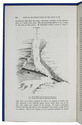
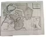
Navigating the waters around Texel

BRANDLIGT, Laurens. 
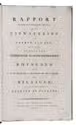
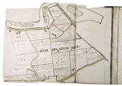
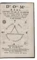
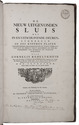
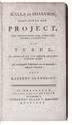
Scylla en Charybdis; behelzende een project, ter verbetering der zeegaten en het vaarwater van Texel, en aanwinning van eenige duizend morgen land.
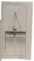
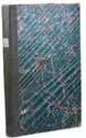
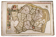
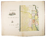
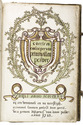
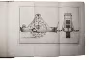
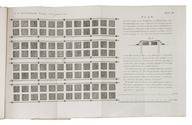
Amsterdam, Johannes Allart, Laurens Brandligt, 1780. 8vo. With 4 folding engraved maps, and 1 folding engraved plate. Contemporary gold-tooled mottled calf, with a red morocco title label on the spine, lettered in gold. XIII, [1], 194 pp. Full description
€ 2,750
Order Inquire Terms of sale

A demonstration of Dutch water management skills

CONRAD, Frederik Willem, Arie Jansz. BLANKEN and Simon KROS. Rapport wegens het onderzoek omtrent eene uitwatering te Catwyk aan Zee, gedaan in 1802. Op last van dykrichter en hoogheemraaden van Rhynland.
Haarlem, François Bohn, 1803[-1804]. Folio. With 2 folding engraved maps, 15 folding engraved plates, and 1 engraved plate, all except one signed by Daniel Veelwaard. Later green half cloth, marbled paper sides. [1], [1 blank], 49, [1 blank], 27, [1] pp. Full description
€ 950
Order Inquire Terms of sale

Beautiful atlas of the Land van Voorne, in full contemporary colour

DIJCK (DYCK), Heyman van. Voorne caart-boeck van alle de dorpen, en polders gelegen inden lande van Oost, ende West Voorne, mitsgaders over Flacquée.
[Netherlands, ca. 1701]. Imperial folio (ca. 55 x 38 cm). Etched double-page title-page by Romeyn de Hooghe, dated "1701", and 32 engraved double-page maps (numbered I- VI, A-F and 1-9) engraved by Jan Stemmers and etched by Jan and Caspar Luyken after drawings by A. Steyaart, all in beautiful contemporary colouring. Contemporary red half sheepskin. Full description
€ 25,000
Order Inquire Terms of sale

Beautiful hand-coloured wall map of Rijnland

DOU, Jan Jansz. (Johannes Dou I), Steven van BROECKHUYSEN and Melchior BOLSTRA. 'T Hooge Heemraedschap van Rhynland.
[Amsterdam], Isaak Tirion, 1746. Atlas folio (58.5 x 37.3 cm). With 15 double-page engraved plates, all coloured by hand, including 13 maps. The plate size is mostly ca. 44.5 x 55 cm and ca. 41.5 x 55 cm, the map of the Haarlemmermeer has plate size 55 x 63 cm. An illustration of existing and projected sluices for drainage of the polder and another illustration with title, both after drawings by Melchior bolstra. All plates mounted on stubs so that they open flat. Half red sheepskin and intricately marbled paper sides. Full description
€ 6,000
Order Inquire Terms of sale

Manuscript atlas and ownership records of parcels in the Prins Willem polder,
northeast of Oostburg, in the southwest corner of the Netherlands

GERSOM, Gerrit van. Caerte en omlooper van Prins Willem Polder. Bedijkt anno 1650 en 1651. ...
[Oostburg?], 1723. Royal folio (41 x 27.5 cm). With a hand-coloured title page, a large folding map of the dikes along the border of the polder, a large folding general map of the polder showing the numbered parcels at a scale of about 1:18,000, and 17 folding detail maps showing the individual plots within the parcels at a larger scale, all executed in brown ink and watercolours and tipped onto the fore-edges of 19 of the 144 numbered text leaves. Contemporary sheepskin parchment. 151 ll. (ll. 1 & 145-151 blank). Full description
€ 9,500
Order Inquire Terms of sale

Topographical wall map of the Dutch (polder) district Vijfheerenlanden,
including the very rare engraved borders with coats of arms

OTTENS, Reinier and Josua OTTENS. Nieuwe kaart van de Vyf Heeren landen gelegen tusschen den Dief en Zouwen dyk.
Amsterdam, Reinier and Josua Ottens, 1741. Engraved map on 4 sheets (85 x 98 cm as assembled), with an engraved title ("Kaart van de Vyf Heerenlanden") with the coat of arms of the water district at the head, and surrounded by 14 engraved coats of arms at the left, right and foot (measuring 122 x 134 cm in total). The map with the title and publisher at the foot left, together with a scale (ca. 1:19,000) and the name of the engraver at the right (Jan van Jagen). Framed. Full description
€ 6,500
Order Inquire Terms of sale

New designs for a sluice and dredging machine, beautifully illustrated, presentation copy to Christiaan Brunings, inspector of the original design and writer of a preliminary text

REDELYKHEID, Cornelis. De nieuw uitgevonden sluis met in- en uitschuivende deuren.
With: (2) REDELYKHEID, Cornelis. De nieuw uitgevonden diep-machine.
The Hague, Hendrik Christoffel Gutteling; Amsterdam, Jacob Yntema & Jacob Tieboel; for the author, 1774. 2 works in 1 volume. Large folio (49.5 x 31 cm). Ad 1 with 6 large folding engraved plates and ad 2 with 3 large folding engraved plates. Contemporary half calf. XII, 26; XI, [1], 18 pp. Full description
€ 7,500
Order Inquire Terms of sale

The use of locally baked bricks for the reinforcement of Dutch dikes

WILDEMAN, Jan Ernst. Verslag eener proeve van het vormen, bakken en gebruiken van zware tigchelsteenen, voor het maken van steenglooijingen, of tot dekking der glooijingen van dijken.
Amsterdam, Pieper en Ipenbuur, 1825. 8vo. With 3 large, folding engraved plates. Contemporary red sprinkled boards. 24 pp. Full description
€ 850
Order Inquire Terms of sale
17 books found / Show all