Categories
Shopping cart (0 items € 0)
Advanced search

Africa / Cartography, Exploration, Travel & Voyages

Adventurous travels in the East

MANDELSLO, Johann Albrecht von. Morgenländische Reyse-Beschreibung.
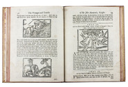
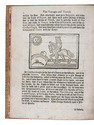
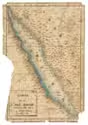
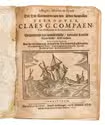
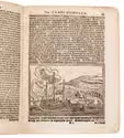
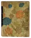
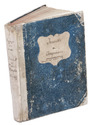
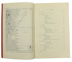
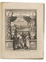
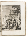
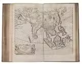
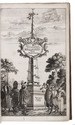
Hamburg, Christian Guth, printed by Johan Holwein, Schleswig, 1658. Folio. With engraved frontispiece by Christian Rothgiesser, engraved author's portrait, double-page engraved map, and 21 large engravings in text, mostly signed by Rothgiesser. Contemporary pigskin, with boards blind-tooled in a panel design. [32], 248, [36] pp. Full description
€ 11,000
Order Inquire Terms of sale

14th-century tales of travels in Turkey, the Middle East, Near East, India and the East Indies,
illustrated with about 60 woodblocks

MANDEVILLE, John [= Jehan d'OUTREMEUSE]. The voyages & travels of Sir John Mandevile, Knight, ... to the Holy Land, and to Hierusalem: as also to the lands of the Great Caan, and of Prestor John: to Inde, and divers other countries: ...
London, Richard Chiswell, Benjamin Walford, Matthew Wotton, George Conyers, 1696. 4to. With a woodcut ship on the title-page and about 60 woodcut illustrations in the text (mostly about 5.5 x 8 cm) plus about 10 repeats. Gold-tooled, red goatskin morocco by Robert Riviere in London (ca. 1875/80), one of England's best binders. [4], “139” [= 135], [5] pp. Full description
€ 22,500
Order Inquire Terms of sale

Scurvy and contagion between the Cape of Good Hope and Batavia:
medical reports of the Dutch East India Company

[MANUSCRIPT - DUTCH - VOC - HEALTH]. Ziekten aan boord der uitvarende schepen naar Indië 1774-1783.
1774-1783. Folio. Loosely inserted in contemporary wrappers with the manuscript title on the front. The work is kept in a brown cloth folder, with a red morocco title label on the front, lettered in gold. [5] ll. Full description
€ 8,500
Order Inquire Terms of sale

Cross-cultural mapping of the Red Sea: Bruce's chart in an early Egyptian manuscript copy

[MAP - ARABIAN PENINSULA]. BRUCE, James. Carte de la mer Rouge, relevée sur celle de James Bruce.
[Egypt, probably Cairo], 1827. Folio leaf (46 x 31.5 cm). Manuscript map in pen and ink with watercolour, with a French text on Middle Eastern hand-made paper. Full description
€ 15,000
Order Inquire Terms of sale

The first printed biography of a pirate: Claes Compaen and the ambiguities of Dutch freebooting

[MARITIME HISTORY - PIRACY - CLAES COMPAEN]. 't Begin, midden en eynde der zee-rooveryen, van den alder-fameusten zee-roover, Claes G. Compaen, van Oostzanen in Kennemerlandt. vervattende sijn wonderlijcke, vreemde landts schadelijcke drijf-tochten. waer in vertoont wordt hoe hy met weynigh schepen de zee onveyligh ghemaeckt, een ongelooflijcken buyt, en groot getal van schepen, van alle landen gerooft, en af geloopen heeft.
Amsterdam, Michiel de Groot, 1675. 4to (19.1 x 14.5 cm). With a large woodcut illustration of a Dutch merchant ship on the title page, 3 woodcut illustrations in the text (including a repeat of the woodcut on the title page), and a large decorated woodcut initial. Contemporary multicolour brocade paper wrapper, covered with protective clear plastic. [6], 42 pp. Full description
€ 7,500
Order Inquire Terms of sale

Blown off course: a trade mission to Vietnam ends badly

MÉNIOLLE, François Valentin. Journal et Correspondance, Septembre 1817 à Février 1819. [Narrative of a failed trade mission to Vietnam and India].
[India and other places, 1817-1819]. 4to (ca. 18 x 22 cm). French manuscript on laid paper. Contemporary half vellum. 95, [ca. 78 blank] ll. Full description
€ 12,500
Order Inquire Terms of sale

Highly detailed maritime atlas

GREAT BRITAIN METEOROLOGICAL OFFICE. Monthly current charts for the Indian Ocean. From information collated & prepared in the Meteorological Office.
London, Admiralty Hydrographic Office, under the superintendence of Rear-Admiral W. J. L. Wharton, 1895-1896. Plano. Oblong Royal 1mo (full-sheet leaves: 51 x 62 cm). An atlas of 12 large black and white nautical charts. Limp cloth with gold-tooled title on front cover. [12] ll. plus the 1-page “Advertisement”. Full description
€ 3,500
Order Inquire Terms of sale

The climate of the East African coast

[METEOROLOGICAL OFFICE - EAST AFRICA]. Weather in the Indian Ocean to Latitude 30° S. and Longitude 95° E. Including the Red Sea and Persian Gulf. Volume II. Local information. Part 9 Coast of East Africa from the equator to Cape Delgado [...].
London, Meteorological Office, Air Ministry, 1940. 8vo. With map frontispiece and several illustrations and tables in the text. Original publisher's printed red wrappers. 63, [1 blank] pp. Full description
€ 1,500
Order Inquire Terms of sale

In search of curiosities in the West Indies, Africa, and the Holy Land

MOCQUET, Jean. De grote nieuw-bereisde wereld: begrypende zes reizen, zo na Lybien, d'Eilanden van Kanarien en Barbaryen; stroom der Amazonen, Karipouzen en Karibanen; na Marocco; Moren-Land of Ethiopien, Mozambique en Goa; als mede na Syrien en een zeer nauwkeurige beschrijvinge van't Heilig Land ... Den tweden druk.
Leeuwarden, Jan Klassen (colophon: printed by Meindert Injema), 1717. 4to. With an engraved title-page, 3 etched plates, and some woodcut decorated initials and tail pieces. Contemporary vellum, later endpapers. [19], [1 blank], 195, [1 blank] pp. Full description
€ 1,950
Order Inquire Terms of sale
147 books found / Show all