
The first complete account of the Le Maire-Schouten expedition
HERRERA Y TORDESILLAS, Antonio de.
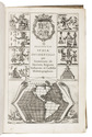
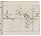
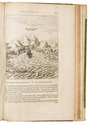
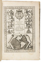
Novis orbis, sive descriptio Indiae Occidentalis ... Methaphraste C. Barlaeo. Accesserunt & aliorum Indiae Occidentalis descriptiones, & navigationis nuperae Australis Jacobi le Maire Historia, uti & navigationum omnium per Fretum Magellanicum succincta narratio.
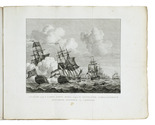
Amsterdam, Michiel Colijn, 1622. Folio. With an engraved title, 17 engraved maps (1 folding, 16 double-page), a full-page portrait, and 4 half-page illustrations in the text. Later three-quarter vellum, with the manuscript title on the spine, sprinkled paper sides, red edges. [4], "81" [=84], [2], "9" [=10], 11, [1 blank] ll. Full description
€ 20,000
Amsterdam, Michiel Colijn, 1622. Folio. With an engraved title, 17 engraved maps (1 folding, 16 double-page), a full-page portrait, and 4 half-page illustrations in the text. Later three-quarter vellum, with the manuscript title on the spine, sprinkled paper sides, red edges. [4], "81" [=84], [2], "9" [=10], 11, [1 blank] ll. Full description