Categories
Shopping cart (0 items € 0)
Advanced search

Cartography & Exploration

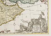
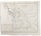
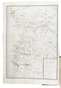
Afghanistan and its dependencies in Persia, Tartary and India, with 14 hand-coloured plates, in original wrappers

ELPHINSTONE, Mountstuart. 
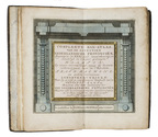
Tableau du royaume de Caboul, et de ses dépendances, dans la Perse, la Tartarie et l'Inde, offrant les moeurs, usages et costumes de cet empire, ... traduit et abrégé de l'anglais, par M. Breton.
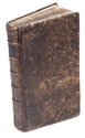
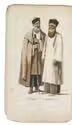
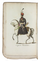
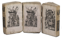
Paris, Nepveu, 1817. 3 volumes. 18mo. With 14 engraved plates depicting various costumes, lords on horseback, etc., all beautifully coloured by hand. Original publisher's printed wrappers, each volume with wood engraved illustrations on front, back and spine. Preserved in a modern gold-tooled green morocco box. XLIV, 189 [3]; [4], 222, [2]; [4], 223 [1] pp. Full description
€ 4,950
Order Inquire Terms of sale

Pocket atlas of the Low Countries with the world & the continents

ELWE, Jan Barend. Compleete zak-atlas, van de zeventien Nederlandsche Provinciën.
Amsterdam, J.B. Elwe & D.M. Langeveld, 1786. 8vo. With a double-page engraved title, 29 numbered folding engraved maps (the first 5 signed by A. van Krevelt) and 2 folding engraved tables, all coloured by a contemporary hand. Contemporary half calf, gold-tooled spine. 239, [1] pp. Full description
€ 2,950
Order Inquire Terms of sale

Pocket atlas of the Low Countries with the world and the continents,
coloured by a contemporary hand

ELWE, Jan Barend. Compleete zak-atlas, van de zeventien Nederlandsche provinciën, begreepen in XXXI ... in 't koper gebragte kaarten.
Amsterdam, Jan Barend Elwe and Dirk Meland Langeveld, 1786. 8vo. With double-page engraved title-page, 29 folding engraved maps and 2 folding engraved tables, all coloured by a contemporary hand. Contemporary half calf, rebacked with the original gold-tooled backstrip. 243, [1] pp. text Full description
€ 2,950
Order Inquire Terms of sale

Beijing in the late 19th century, illustrated with numerous photographs

FAVIER, Alphonse. Péking histoire et description.
Peking, Imprimerie des Lazaristes au Pe-Tang, 1897. 35.5 x 25.5 cm. 2 volumes bound as 1 (continuous page numbers). With a frontispiece to each part, 51 plates with photolithographs and collotypes, 1 tinted map and 660 wood engraved illustrations in text. Modern half cloth, with the original wrappers bound in. XII [4], 336, [4], 337-“562” [=552], [2] pp. Full description
€ 6,500
Order Inquire Terms of sale

The division of Oregon Country between Britain and the United States of America

FÉDIX, P.A. L'Orégon et les côtes de l'Océan Pacifique du Nord, aperçu géographique, statistique et politique, avec une carte du pays d'après les documens les plus récens.
Paris, Librairie de Amyot (printed by Éd. Proux et Cie), 1846. 8vo. With a large folding map (40 x 52.5 cm) depicting what the United States called Oregon Country, dated 1846 and partly coloured in outline. Modern maroon half morocco. 258 pp. Full description
€ 9,500
Order Inquire Terms of sale

First printing of a rare 18th-century map of Portuguese Angola

FEO CARDOZO DE CASTELLOBRANCO E TORRES, João Carlos. Memorias contendo a biographia do vice almirante Luiz da Motta Feo e Torres. A historia dos governadores e capitaens generaes de Angola, desde 1575 até 1825, e a descripção geographica e politica dos reinos de Angola e de Benguella.
Paris, Fantin, 1825. 3 parts in 1 volume. 4to. With one large folding map at the start of the first volume, showing the coast of Angola, and a small vignette on the title page. Contemporary gold-tooled tree-marbled calf. [14], 375, [6] pp. Full description
€ 2,950
Order Inquire Terms of sale

First and only Italian edition on French missionaries in Southeast Asia

[FERMANEL DE FAVERY, Luc (editor)]. Relatione delle missioni de' vescovi vicarii apostolici, mandati dalla S. Sede apostolica alli regni di Siam, Cocincina, Camboia, e Tunkino.
Rome, printed by the Sacra Congregatio de Propaganda Fide, 1677. 4to. Modern vellum. [14], 254, [2 blank] pp. Full description
€ 2,500
Order Inquire Terms of sale

A previously unobtainable set of magnificent wall maps by Nicolas de Fer

FER, Nicolas de. Set of four wall maps: America (1698), Africa (1698), Asia (1696), Europe (1695).
Paris, chez lauteur / van Loon, 1695-1698. Approximately 114.3 x 165.1 cm each. Copperplate engravings in original outline colour, tissue-backed for stability, laid down to modern cartographic linen. All with title banner dated 1698 with the Royal Privilege, and text panels dated 1703. Each map printed on four joined sheets with title surmounted and engraved text panels at sides and bottom. Full description
€ 850,000
Order Inquire Terms of sale
691 books found / Show all