Categories
Shopping cart (0 items € 0)
Advanced search

Cartography & Exploration

Rare journal of De la Salles last American voyage, exploring the Mississippi River,
including the large folding map, rarely included

JOUTEL, Henri (Monsieur DE MICHEL, ed.). Journal historique du dernier voyage que feu M. De la Sale fit dans le Golfe de Mexique, pour trouver l'embouchure & le cours de la riviere de Missicipi, nommée à présent la rivière de Saint Louis, que traverse la Louisiane. Où on voit l'histoire tragique de sa mort, & plusieurs choses curieuses du nouveau monde.
Paris, Estienne Robinot, 1713. 12mo. With a large folding engraved map. Contemporary calf. XXXIV, 386 pp. Full description
€ 10,000
Order Inquire Terms of sale

One of the most comprehensive accounts of 18th-century South America,
especially valuable for Panama, Peru and Ecuador

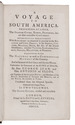
JUAN, Jorge and Antonio de ULLOA. A voyage to South America. Describing at large, the Spanish cities, towns, provinces, &c. on that extensive continent.
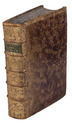
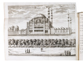
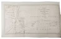
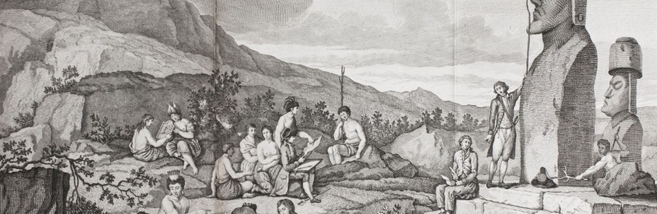
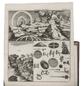
London, L. Davis and C. Reymers, 1760. 2 volumes. 8vo. With 7 folding engraved plates, including some maps and ground plans. Contemporary calf, gold-tooled spine; rebacked, with the original backstrip laid down. XX, [4], 498 [=488]; [4], 410, 18 pp. Full description
€ 1,800
Order Inquire Terms of sale

The most extensive, precise and complete descriptions of Java ca. 1850, beautifully illustrated

JUNGHUHN, Franz Wilhelm. Java, zijne gedaante, zijn plantentooi en inwendige bouw. ... Tweede verbeterde uitgave.
Including: JUNGHUHN, Franz Wilhelm. Atlas van platen, bevattende elf pittoreske gezigten. − Behoorende tot het werk Java, zijne gedaante, zijn plantentooi en inwendige bouw.
Den Haag, C.W. Mieling, 1853-1854. 4 text volumes and 1 plates volume. Large 8vo (26 x 17.5 cm: text volumes 1-4) and large folio (44 x 31.5 cm: plates volume). Each text volume with a lithographic title-page, vol. 1 with the text blue on white and vols. 2-4 with the text white on buff; the plates volume with a double-page letterpress title-page. Further with 12 double-page chromolithographed or double-tinted lithographed views: 1 as frontispiece to vol. 1 and 11 (43 x 58 cm; image 31 x 43 cm to 38 x 54 cm, 5 numbered VII, VIII, X, XI & XV) in the atlas volume; most in black, buff and blue and at least most drawn by Junghuhn and lithographed by Mieling (all but the frontispiece signed by the latter), and 51 black and white lithographic plates (45 folding) with topographic maps, views, cross-sections, etc. Contemporary half red sheepskin(?), (text vols.) and goatskin morocco (atlas vol.), gold-tooled spines. Bound by Hendrik Willem Ywema (1828-1905) in Utrecht. 16, VIII, 17-671; XII, 538; 539-1432; VIII, 498 pp. plus title-pages & plates. Full description
€ 32,500
Order Inquire Terms of sale

Important collection of voyages to America and Africa, together with a standard work on Constantinople

[JUSTEL, Henri]. Recueil de divers voyages faits en Afrique et en l'Amerique.
Paris, Louis Billaine, 1674. With 17 engraved plates: 5 maps (4 folding), 3 folding plans and 9 other illustrations.
With: (2) GRELOT, Guillaume-Joseph. Relation nouvelle d'un voyage de Constantinople.
Paris, Nicolas Belley, 1689 (colophon 1680). With engraved portrait of a saint on title-page, 13 engraved plates, 4 engravings in text and engraved coat of arms. 2 works in 1 volume. 4to. 18th-century tan calf, gold-tooled spine. [16], 262, 35 [1 blank], 23 [1 blank], 49 [1 blank], [2], 81 [1 blank]; [12], 306, 1 [1 blank] pp. Full description
€ 18,000
Order Inquire Terms of sale

The main source of early knowledge of the Pelew or Palau Islands in Micronesia, in Dutch translation

KEATE, George. Beschryving van de Pelew Eilanden ...
Rotterdam, Gerard Abraham Arrenberg, 1789. 4to. With 8 plates: 4 mixed technique (partly stipple-engraved) portraits, 1 large folding engraved map of the Palau Islands and western equatorial Pacific, and 3 folding engraved views. Contemporary boards. XXXII, 365, [1] pp. Full description
€ 2,500
Order Inquire Terms of sale

Eyewitness report of the dramatic shipwreck of the Dutch East Indiaman Arnhem
and the survival of its castaways on Mauritius

KERCKHOVEN, Johannes van [= Simon van den KERKHOVEN]. Wijtloopig breede en waerachtige beschrijvinge van de ongeluckige voyage van t schip Aernhem; van Batavia vertrocken den 23 December 1661 in compagnie van noch ses andere schepen, onder t commando van de heer Aernout de Vlamingh van Outshoorn ...
Amsterdam, Jacobus van der Fuyck, 1664. 4to. With a woodcut vignette on the title page and 2 decorated woodcut initials. Disbound, loosely inserted in 20th-century plain brown paper wrappers. “28” [= 24] pp. Full description
€ 2,500
Order Inquire Terms of sale

Very rare Dutch picaresque novel, with the female protagonist getting caught by pirates
and ending up in the household of an Arabic slave trader

[KERSTEMAN, Petrus Lievens]. De vermakelyke avanturesse, of de dienstmaagd van fortuin. Vervattende hare zonderlinge levensgevallen, ontelbare wederwaardigheden en rampen; zeltzame ontmoetingen, en koddige vryagien; deszelfs driejarige dienst als lakye, gevangenneming op de Moorsche kusten, en hare slavernye in Asia by de Arabieren.
Amsterdam, Steven van Esveldt, 1754. 8vo. With engraved frontispiece. Contemporary mottled half calf, gold-tooled spine, later endpapers. [4], 360 pp Full description
€ 3,500
Order Inquire Terms of sale

Spectacular 18th-century Dutch composite sea atlas with 3 detailed manuscript charts,
all charts and the engraved title page expertly coloured by a contemporary hand

[KEULEN, Gerard and Johannes van, and others]. [Composite sea atlas containing 56 detailed charts including 3 manuscript charts].
Amsterdam, [Johannes van Keulen and others, 1700-1753, engraved title page dated 1734]. Large folio (61.5 x40.5 cm). With an engraved allegorical title page by Aernout Nagtegael after Jan Luyken, and 56 detailed sea charts, the whole expertly coloured by a contemporary hand. The atlas includes 22 large folding charts, including 3 highly interesting manuscript charts, 27 double-page charts, 1 full-page chart, and 6 half-page charts, most of them with beautiful cartouches, depicting views, local people, and merchandise. The maps are engraved and originally edited by the most famous Dutch cartographers and map-publishers of the late 17th- and early 18th centuries. Contemporary blind-tooled vellum, with green cloth closing ties. Title page and 56 charts. Full description
€ 600,000
Order Inquire Terms of sale

Concise handbook for Western travellers visiting the Gulf States

KILNER, Peter and Jonathan WALLACE (editors). A guide for businessmen and visitors. The Gulf handbook 1978.
Bath and London, Trade and Travel Publications and MEED, 1978. 17.5 x 12 cm. With 8 sections of a map (2 full-page and 3 double-page) in colour of showing several parts of the Arabian peninsula, 8 full-page black-and-white photographic portraits of the Heads of State of the different Gulf States, 21 black-and-white maps and plans of these states and their largest cities, and numerous advertisements (partially in colour) throughout. Original illustrative printed boards, showing an Arab man with a gun in front of a large satellite dish and an advert for Arab Wings showing a plane in the sky on the back. XII, 576 pp. Full description
€ 350
Order Inquire Terms of sale

Lively watercolour view of Tophane Quay in Istanbul with the Kilic Ali Pasha Mosque

[ISTANBUL]. [KING, Helena Caroline or Adelaide Charlotte]. [Prominent Ottoman and entourage boarding boats before the Kilic Ali Pasha Mosque].
[Istanbul?, ca. 1830/50?]. Watercolour drawing on wove paper (29.5 x 45 cm) with highlights in shellac and a thin black border. Mounted on a larger sheet of paper in a passe-partout. Full description
€ 8,500
Order Inquire Terms of sale
693 books found / Show all