Categories
Shopping cart (0 items € 0)
Advanced search

Cartography & Exploration / Asia

The second voyage of Paul Lucas through the Levant

LUCAS, Paul. Voyage du sieur Paul Lucas fait par ordre du Roi dans la Grèce, L'Asie Mineure, La Macedoine et L'Afrique. Contenant la description de la Natolie, de la Caramanie, & de la Macedoine.
Amsterdam, aux dépens de la Compagnie, 1714. 2 parts in 1 volume. 12mo. With an engraved frontispiece and a title-page printed in red and black for each part, 9 folding engraved plates with pyramids, archeological findings, the Holy Grave, and inscriptions, 2 folding engraved maps of the Levant (engraved by B. Ruyter), and of Fioum, the Nile and surroundings in Egypt, and 8 full-page engraved plates. Contemporary half calf. [1], [1 blank], [28], 323, [1 blank]; [1], [1 blank], [8], 328 pp. Full description
€ 3,500
Order Inquire Terms of sale

Adventurous travels in the East

MANDELSLO, Johann Albrecht von. Morgenländische Reyse-Beschreibung.
Hamburg, Christian Guth, printed by Johan Holwein, Schleswig, 1658. Folio. With engraved frontispiece by Christian Rothgiesser, engraved author's portrait, double-page engraved map, and 21 large engravings in text, mostly signed by Rothgiesser. Contemporary pigskin, with boards blind-tooled in a panel design. [32], 248, [36] pp. Full description
€ 11,000
Order Inquire Terms of sale

14th-century tales of travels in Turkey, the Middle East, Near East, India and the East Indies,
illustrated with about 60 woodblocks

MANDEVILLE, John [= Jehan d'OUTREMEUSE]. The voyages & travels of Sir John Mandevile, Knight, ... to the Holy Land, and to Hierusalem: as also to the lands of the Great Caan, and of Prestor John: to Inde, and divers other countries: ...
London, Richard Chiswell, Benjamin Walford, Matthew Wotton, George Conyers, 1696. 4to. With a woodcut ship on the title-page and about 60 woodcut illustrations in the text (mostly about 5.5 x 8 cm) plus about 10 repeats. Gold-tooled, red goatskin morocco by Robert Riviere in London (ca. 1875/80), one of England's best binders. [4], “139” [= 135], [5] pp. Full description
€ 22,500
Order Inquire Terms of sale

A 19th-century tourist's experiences during his travels to the Philippines

MAN, Jules de. Souvenirs d'un voyage aux Iles Philippines.
Antwerp, Imprimerie Stockmans & Moerincx, 1875. 8vo (22 x 15 cm). With 8 albumen prints, including 3 reproductions of drawings, representing the local population, mounted within printed frames on separate leaves with printed captions below. Original publisher's gold- and blind stamped red pebble-grained cloth, yellow endpapers. 268 pp. Full description
€ 2,950
Order Inquire Terms of sale

Secret military expedition to China

MANNERHEIM, Carl Gustav. Across Asia from West to East in 1906-1908.
Helsinki, Suomalais-Ugrilainen Seura, 1940. 2 volumes. (30.5 x 22 cm). With numerous illustrations in text, one small map after the preface, and 15 folding maps in the second volume. Half sheepskin, cloth sides. IV, 741; IV, 54, 16, 48, 36, 36, 12, 6, 30, 12 pp. Full description
€ 9,500
Order Inquire Terms of sale

Cross-cultural mapping of the Red Sea: Bruce's chart in an early Egyptian manuscript copy

[MAP - ARABIAN PENINSULA]. BRUCE, James. Carte de la mer Rouge, relevée sur celle de James Bruce.
[Egypt, probably Cairo], 1827. Folio leaf (46 x 31.5 cm). Manuscript map in pen and ink with watercolour, with a French text on Middle Eastern hand-made paper. Full description
€ 15,000
Order Inquire Terms of sale

Asia and the Middle East in 1952, with many borders on the Arabian Peninsula still undefined

[MAP – ASIA – MIDDLE EAST]. NATIONAL GEOGRAPHIC SOCIETY. Southwest Asia, India, Pakistan, and Northeast Africa.
Washington, DC, National Geographic Society, 1952. Colour printed map, 68.5 x 95 cm. Scale 1:7,5000,000. With an inset map of "the Moslem World; percentage of Moslems in total population". Full description
€ 850
Order Inquire Terms of sale

Early 19th-century edition of a woodcut plan imaging Nagasaki and Deshima

[MAP]. BUNKINDO HAN. Hishu Nagasaki (no) zu [= plan of Nagasaki, Hizen province].
[Nagasaki, Bunkindo, 1821]. 61.5 x 87 cm. Large folding woodcut map of the port and city of Nagasaki, printed in three colours (ochre, blue and green) on four sheets. In Japanese ochre paper etui decorated with blue and white flowers and title label with Japanese characters pasted on, preserved in later dark blue cloth slipcase in Japanese style closing with two ivory clasps. Full description
€ 2,950
Order Inquire Terms of sale

Poetic descriptions of Batavia, India, the Cape, Dutch country estates and notable persons

MARRE, Jan de. 
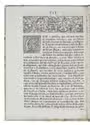
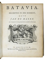
Batavia, begrepen in zes boeken.
Amsterdam, Adriaan Wor & heirs of G. onder de Linden, 1740.
With:
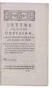
(2) MARRE, Jan de. Bespiegelingen over gods wysheid in't bestier der schepselen, en eerkroon voor de Caab de Goede Hoop.
Amsterdam, Adriaan Wor & heirs of G. onder de Linden, 1746.
(3) MARRE, Jan de. Hof- en mengeldichten.
Amsterdam, Adriaan Wor & heirs of G. onder de Linden, 1746.
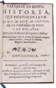
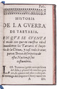
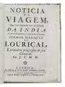
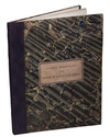
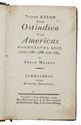
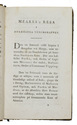
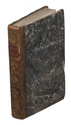
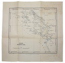
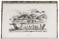
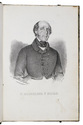
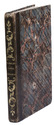
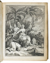
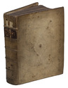
3 works in 1 volume, the first in 6 parts. 4to. With an engraved frontispiece and an elaborate title-vignette (identical on all three title-pages. And ad. 1 with a folding engraved plate of Jakarta "as it was in 1731" by Jan van der Laan. Contemporary vellum, red spine label. [36], 320, [6]; [42], 178, [22], [20], 214, [4] pp. Full description
€ 1,500
Order Inquire Terms of sale
173 books found / Show all