Categories
Shopping cart (0 items € 0)
Advanced search

Cartography & Exploration / Atlases, Charts, Maps & Globes

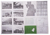
8 complete print series with text, forming the collected architectural work of Pieter Post

POST, Pieter. Les ouvrages d'architecture.
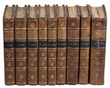
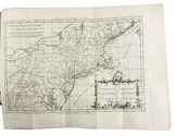
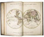
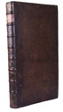
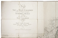
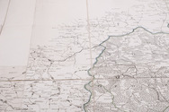
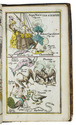
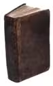
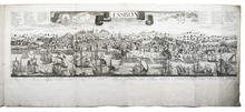
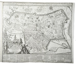
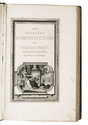
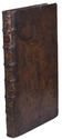
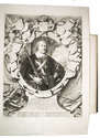
Leiden, Pieter van der Aa, 1715. 8 parts in 1 volume. Royal folio (46 x 29.5 cm). With an engraved general title-page with a rectangular frame and a cartouche with Athena, architecture books and buildings, letterpress general title-page in red and black with engraved vignette (Athena with a view of Leiden, drawn by J. Goeree), 8 letterpress part-titles, 3 engraved part-titles, engraved dedication, a folding engraved portrait of Prince Johan Maurits after Govert Flinck by C. van Dalen (filling a whole Imperial sheet: plate size 60.5 x 46 cm!), and 8 series of 6, 12, 8, 5, 11, 7, 4 and 23 mostly double-page and some larger folding etched and engraved numbered plates after designs by Pieter Post, showing architectural plans, elevations, sections, etc. In total about 80 copperplates. Mottled calf (ca. 1750). [8], 6; 8; 10; 8; 12; 5, [1 blank]; 6; [2], 8 pp. plus plates. Full description
€ 12,500
Order Inquire Terms of sale

One of the earliest maps of Arabia, with unique contemporary illumination

[MAP - ARABIAN PENINSULA]. PTOLEMAEUS, Claudius. [Jacobus ANGELUS, trans.; Nicolaus GERMANUS, ed.]. Sexta Asie Tabula.
Ulm, Lienhart Holle, 1482. Oblong 1mo (whole sheet: 41.5 by 57 cm). With a double-page woodcut map. Finely coloured by a contemporary hand, with near-contemporary manuscript vignette illustrations of an Ababeel bird, Makkah (Mecca) and the Kaaba in pen and wash highlighted in gold. Full description
€ 150,000
Order Inquire Terms of sale

Second map of the Arabian peninsula ever published

[MAP - ARABIAN PENINSULA]. PTOLEMAEUS, Claudius. Sexta Asiae tabula.
[Rome, Petrus de Turre, 1490 (engraved Rome, ca. 1478)]. Engraved map of the Arabian peninsula (topographic image 25.5 x 46 cm) printed, as usual, on two joined folio leaves (together 39.5 x 56 cm). Mounted on paper board, in a modern gilt frame (50.5 x 67 cm). Full description
€ 50,000
Order Inquire Terms of sale

Radical critique of European overseas expansion in 10 volumes. Extremely rare second Dutch edition

RAYNAL, Guillaume Thomas François. Wysgeerige en staatkundige geschiedenis van de bezittingen en den koophandel der Europeaanen, in de beide Indiën.
Amsterdam, Matthijs Schalekamp, 1792-1803. 10 volumes bound as 9. 8vo. With 2 different engraved author's portraits, 8 engraved plates (5 as frontispieces), 12 engraved folding maps and 23 letterpress folding tables. Contemporary half calf, gold-tooled spine. VI, [4], 469, [19]; [8], 533, [1 blank], 11, [1 blank]; [8], 508, [11], [1 blank]; [8], 427, [9], [2 blank]; [8], 365, [9]; [8], 426, [10]; [10], 501, [7]; [8], 458, [11], [1 blank]; [8], 339, [10], [1 blank]; [4], 432, [13], [1 blank] pp. Full description
€ 7,500
Order Inquire Terms of sale

Magnificent Dutch sea atlas of the world

RENARD, Louis. Atlas van zeevaert en koophandel door de geheele weereldt. Vertoonende in bizondere op elkander volgende kaerten, alle desselfs zeekusten en haevens; met beschryvingen van de natuur, voortbrengsels, handwerksels, godsdiensten, bestier en koophandel van alle gewesten, &c. Voorheen in de Fransche taele uytgegeven door den heer Louis Renard, agent van zyne Majesteit van Groot-Brittannien. En nu alle de kaerten op 't naeukeurigste met hulpe van voornaeme kundigen naer de laetste ontdekkingen vernieuwt; en een groot getal plaetsen neevens verscheide nieuwe kaerten daer ingebragt. Door Reinier en Iosua Ottens. De beschryvingen met veele vereischte zaeken vermeedert, en naer den tegenwoordigen tydt geschikt. By de nieuwe kaerten, beschryvingen gevoegt; en met natuurkundige aenmerkingen over de sterre- en aerdtrykskunde, zeën en winden &c. verrykt. Door Ian van den Bosch Melchiorsz.
Amsterdam, Reinier & Josua Ottens, 1745. Large folio (55 x 36.5 cm). With an engraved title page, a letterpress title page printed in red and black, an engraved dedication, 4 large folding maps (ca. 52 x 90-150 cm) and 28 double page maps, the majority with striking allegorical cartouches and all beautifully contemporary hand coloured in outline and with additional gouache washes. Contemporary calf, gold-tooled spine in nine compartments with a stamp of an armillary sphere in gold and a red sheepskin title label, lettered in gold, decorated ("marbled") edges. [1], [1 blank], [4], 152 pp. Full description
€ 75,000
Order Inquire Terms of sale

Very interesting large folding map of Galicia (southeastern Poland) as part of the Habsburg Empire

REYMANN, Daniel Gottlob. Karte eines Theils von Neu oder West Gallicien welcher die Woywodschaften Sendomier und Krakau enthält nebst einem Theil von Alt Gallicien in XII Blatt, entworffen von Daniel Gottlob Reymann Königl: Preuss: Plan Kammer Inspector und Ingénieu Géographe.
[Berlin, S. Schropp & Comp.,] 1797. Engraved map in 12 sheets, cut into 49 (7 x 7) sections (each ca. 22 x 21 cm) with a total size of 154 x 154 cm. Scale ca. 1:180,000. Partly hand-coloured in outline. Mounted on linen. Full description
€ 2,500
Order Inquire Terms of sale

Celestial atlas containing an introduction on astronomy,
with 38 contemporary hand-coloured plates showing celestial maps, spheres, constellations etc.

MEIJLAN, Johann Leonard. Atlas portatilis coelestis. Oder Compendiöse Vorstellung des gantzen Welt-Gebäudes in den Anfangs-Gründen des wahren Astronomie...; sondern auch zugleich daraus, sich einen bessern Begriff von dem wahren Fundament sowol der Geographie als Schiffahrt zueignen kan.
Nürnberg, Johann Christoph Weigel, printed by Johann Ernst Adelbulner, 1723. Large 8vo. With a double-page title-page printed in red and black and XXVIII (38) engraved plates (1 double-page) with celestial maps, globes, armillary spheres and astronomical diagrams and constellations, coloured by a contemporary hand and tipped onto the fore-edge, folding out so that they can be viewed while reading the book. Contemporary calf. [16], 362, [22] pp. Full description
€ 3,500
Order Inquire Terms of sale

The great Lisbon earthquake of 1755 and the city of Augsburg: a splendid publication with more than 100 engraved maps, plans and views, in an Augsburg gold-brocade paper wrapper

ROTH, Johann Michaël. Augsburgische Sammlung derer wegen des höchstbetrübten Untergangs der Stadt Lissabon, ... anbey hat man die Stadt Augsburg in Grundriß mit 48. Prospecten der schönsten Gebäude denselben mit beygefüget ...
Augsburg, Johann Michael Roth, [ca. 1756].
Including:
(2) [MAP - GERMANY - AUGSBURG]. KRAUS, Johann Thomas. Accurata recens delineate ichnographia ... metropolis Augustae Vindelicorum ... = Neu verfertigt accurater Grund Riß der ... Statt Augspurg, ...
Augsburg, Matthäus Seutter, [ca. 1750]. Large engraved map on a folding sheet (50 x 61 cm) at a scale of about 1:4000.
(3) WEYERMANN, Jakob Christoph. Prospectus praecipuorum aedificorum et locorum intra et extra urbem Augustam Vindelicorum ...
Augsburg, Matthäus Seutter, 1742. 4 large uncut folding sheets (each 40 x 70 cm) containing the engraved title-page in an elaborately decorated cartouche and 47 engraved views of buildings in and around Augsburg (each 16 x 13.5 cm), numbered [I], II-XLIII.
1mo (50 x 38.5 cm). With an engraved title-page, the title in the arched doorway of an architectural ruin with a female figure with the Portuguese coat of arms in mourning on the steps, flanked by 2 putti; an engraved report on the earthquake and resulting tsunami on 1 November 1755; and in the first part 60 engraved views, maps and plans printed from 25 copperplates on 13 leaves (4 large folding, including 1 constructed from 2 sheets, the rest on both sides of 9 leaves, except the last, which is blank on the reverse). Gold on black gold brocade paper wrapper, probably from the publisher, sewn without supports at 3 stations, each wrapper made from a whole sheet of the decorated paper, with as centrepiece a statue in a domed gazebo, the dome carried by 4 visible (probably of 6) caryatids. The sheet is further filled with scrollwork decoration with oval portraits in the upper corners, winged angels in the lower corners, 4 more angels plus 2 faces in the scrollwork. Pasted in the centre of the front wrapper is an engraving of the Augsburg pine cone flanked by Neptune with his trident and a river God with an oar, above a city view with cornucopias (10 x 6.5 cm), with a manuscript label below it, "1755 et 1756." The whole is kept is a finely produced modern tanned sheepskin box with the form of a book, the spine with 7 raised bands and a red morocco label, a single brass fastening, and the interior and what would be the edges of the paper lined with marbled paper combining Stormont, zebra and Spanish patterns. [20] engraved ll., some printed on both sides. Full description
€ 47,000
Order Inquire Terms of sale

Road map of Saudi Arabia, with plans of Jeddah, Riyadh and Dammam

[SAUDI ARABIA – MAP]. Road map of Saudi Arabia: accurate and most up to date road map.
Karachi, Pakistan, printed at Golden block works, [1970s]. Colour-printed folding map (48 x 69.5 cm) of the Arabian peninsula (scale: ca. 1:5,000,000), with on the back a city map of Jeddah, a plan of the main business quarter of Riyadh, a city plan of Dammam(?), a distance table and 8 photographic city views. Full description
€ 1,750
Order Inquire Terms of sale
167 books found / Show all