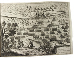

Three fortification plans, including a large coloured plan of the fortifications of Neuf-Brisach
[DRAWING - FORTIFICATION]. GENNEP, T.P. van.
[Three fortification plans].
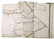
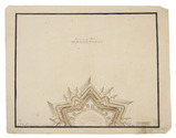
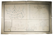
[Raamsdonk], 1798. 3 manuscript fortification plans (measuring (ad 1) 58 x 93 cm, (ad 2) 24.5 x 24.5 cm (ad 3) 29.5 x 37 cm) on paper. All signed: T.P. van Gennep, 1798; and one: Raamsdonk, 29 January 1798. Full description
€ 950
[Raamsdonk], 1798. 3 manuscript fortification plans (measuring (ad 1) 58 x 93 cm, (ad 2) 24.5 x 24.5 cm (ad 3) 29.5 x 37 cm) on paper. All signed: T.P. van Gennep, 1798; and one: Raamsdonk, 29 January 1798. Full description