
Extremely rare bound copy of a mid-19th-century panorama cityscape of the Dutch city of Rotterdam
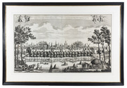
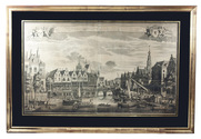
[PANORAMA - ROTTERDAM]. Johan Conrad GREIVE jr. (illustrator).
Panorama de Rotterdam.
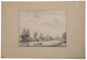
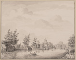
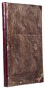
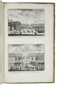
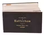
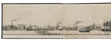
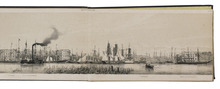
Amsterdam, [printed by R. de Vries for] François Buffa & Sons, [1861]. Oblong (14.5 x 25 cm). The panorama is made up of 6 numbered views, which were originally published on three loose leaves of 2 views per leaf. The viewer looks northward from the river Meuse over the city from the old "sailor's house" (zeemanshuis) in the west along the Willemskade and the Haringvliet to the train station and large warehouse (rijks entrepot) in the east. Original brown blind-stamped wave-grained cloth. 6 numbered views folded making 12 pages. Full description
€ 4,950
Amsterdam, [printed by R. de Vries for] François Buffa & Sons, [1861]. Oblong (14.5 x 25 cm). The panorama is made up of 6 numbered views, which were originally published on three loose leaves of 2 views per leaf. The viewer looks northward from the river Meuse over the city from the old "sailor's house" (zeemanshuis) in the west along the Willemskade and the Haringvliet to the train station and large warehouse (rijks entrepot) in the east. Original brown blind-stamped wave-grained cloth. 6 numbered views folded making 12 pages. Full description