Categories
Shopping cart (0 items € 0)
Advanced search

Cartography, Exploration & Voyages

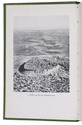
Ship's journal from Seychelles and Madagascar,
with numerous maps and earlier illustrated anatomical lecture notes

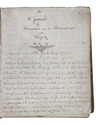
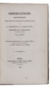
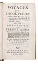
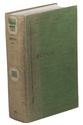
[MANUSCRIPT - SHIP'S JOURNAL]. MORSE, Edward George. A journal of remarks and observations as kept by E. G. M. . ..
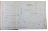
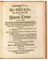
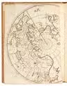
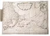
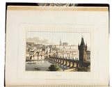
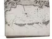
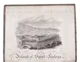
[mostly on board the barque Sarah of London], April 1831-14 March 1833 (with additions to 1835). with an engraved view as frontispiece, 15 full-page, 1 nearly full-page and 1 smaller manuscript maps and coastal profiles, plus a small engraved view ("Tomb of Napoleon") mounted on 1 page.
Including: MORSE, Edward George. Lecture Book [notes on anatomical lectures by Joseph Constantine Carpue].
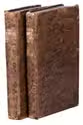
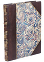
[London], November-December 1828. with a matching pair of engravings of a scull on and facing the title-page, and 27 pencil and/or ink anatomical drawings (including 2 full-page), some also with red. 4to (19.5×16.5 cm). Contemporary sheepskin parchment. [191] ll. Including paste-downs and about 55 blanks. Full description
€ 35,000
Order Inquire Terms of sale

Essays on chronometry resulting from Roquemaurel's circumnavigations
to the Pacific, South East Asia and South America (Brazil)

MOUCHEZ, Amédée Ernest Barthélemy. Observations chronométriques faites pendant la campagne de circumnavigation de la corvette La Capricieuse, commandée par M. Roquemaurel, capitaine de vaisseau.
Paris, Firmin Didot frères, 1855. With 4 folding plates. With:
(2) MOUCHEZ, Amédée Ernest Barthélemy. Longitudes chronométriques des principaux points de la cote du Brésil, rapportées au premier méridien de Rio-Janeiro. Paris, Paul Dupont, 1863.
(3) MOUCHEZ, Amédée Ernest Barthélemy. Positions géographiques des principaux points de la cote orientale de l'Amérique du Sud comprise entre la Guyane Française et le Paraguay. Paris, Paul Dupont, 1868.
3 works in 1 volume. 8vo. Contemporary grained red half sheepskin. VIII, 139, [1]; 32; [4], 35, [1] pp. Full description
€ 3,500
Order Inquire Terms of sale

Uphill! A collection of folders, brochures and books on mountaineering

[MOUNTAINEERING]. [A collection of brochures and folders on mountaineering].
[Austria and Switzerland, ca. 1920- ca. 1980]. Ca. 653 brochures (including a few duplicates and variant issues).
With: [A collection of books relating to mountaineering].
[Globally, ca. 1830- ca. 2000]. Ca. 875 books (including a few duplicates and variant issues, and several multiple-volume titles). Full description
€ 45,000
Order Inquire Terms of sale

With the rare map of the North Pole

MOXON, Joseph. Ein kurtzer Discours von der Schiff-Fahrt bey dem Nord-Pol nach Japan, China, und so weiter. Durch drey Erfahrungen dargethan und erwiesen, nebenst Beantwortungen aller Einwürffe, welche wieder die Fahrt auff diesen Weg können eingewendet worden; Als 1. durch eine Schiffahrt von Amsterdam in den Nord-Pol. 2. durch eine Schiffahrt von Japan, nach den Nord-Pol. 3. durch einen Versuch den der Großfürst in der Moskau thun lassen, worduch erscheinet, daß gegen Norden von Nova Zembla eine frey und offene See ist biß nach Japan China und so weiter; Sampt einer Land-Charte so alle Länder nechst dem Polo anweiset; Aus dem Englischen ins Hochdeutsche übersetzet.
Hamburg, Johan Naumann and Georg Wolff, 1676. 4to. With the last leaf folding, and with a woodcut map of Nova Zembla and the Kara Sea at foot and a large map engraved by Jochim Wichmann on the verso, showing the North Pole and the lands around it including Newfoundland, Baffins Bay, Hudson Straits, Nova Francia, Nova Anglia, and Japan. Later gold-tooled crushed morocco, with a double fillet border with corner pieces on both boards, spine in compartments with gilt decoration, gold-tooled turn-ins. [4] ll. Full description
€ 6,500
Order Inquire Terms of sale

Most extensive edition of a monumental, extensively illustrated description of the world

MÜNSTER, Sebastian. Cosmographia, das ist: Beschreibung der gantzen Welt, ...
Basel, heirs of Sebastian Henricpetri, 1628. Folio (38 x 24.5 cm). With engraved title-page, letterpress title-page printed in red and black with woodcut portrait of Münster on the back, 26 numbered double-page woodcut maps on inserted bifolia, 72 double-page woodcut maps, plans and views on integral leaves, and about 1500 woodcut illustrations in the text (including repeats) showing maps, plans, views, plants, animals, monsters, etc. Contemporary vellum. [24], “1752” [=1748] , [12] pp. Full description
€ 48,000
Order Inquire Terms of sale

Eyewitness account of Captain Bering's famous polar expedition, with the important map of Russia

MÜLLER, Gerhard Friedrich. Voyages et découvertes faites par les Russes le long de côtes de la Mer Glaciale et sur l'Océan Oriental, tant vers le Japon que vers l'Amérique. On y a joint l'histoire du fleuve Amur et des pays adjacens.
Amsterdam, Marc Michel Rey, 1766. 2 volumes. 12mo. With a large folding engraved map of the Russian Far East, from Novaya Zemlya to Kamchatka, with parts of Japan and North America. Contemporary gold-tooled mottled calf. X, [2], 388; IV, 207, [25] pp. Full description
€ 3,500
Order Inquire Terms of sale

For official use only: Royal Navy wartime handbook on Iraq and the Persian Gulf

NAVAL INTELLIGENCE DIVISION. [MASON, Kenneth, a.o.]. Iraq and the Persian Gulf. September 1944. B.R. 524 (restricted) geographical handbook series for official use only.
[Oxford,] Naval Intelligence division, 1944. 8vo. With numerous diagrams, reproductions of photographs and (folding) maps, including a loose map in the pocket at the back. Publisher's green cloth. 682 pp. Full description
€ 3,500
Order Inquire Terms of sale

One of the limited official copies of a geographical handbook on Persia and Arabia

NAVAL INTELLIGENCE DIVISION. Persia. Geographical handbook series for official use only.
(colophon:) Oxford, University Press, September 1945. Large 8vo. With 1 large folding map of Iraq, Arabia and Persia bound at the end of the book, 11 smaller folding maps and 50 illustration figures in the text (smaller maps, current and wind charts, sections, diagrams on the rainfall, etc.). Also with 337 half-tone photographs, inserted on separate leaves and all numbered and captioned. Original publisher's green cloth, gilt-lettering on front board and spine. XIX, [1 blank], 638 pp. Full description
€ 1,250
Order Inquire Terms of sale

Eyewitness account of the horrors of the Napoleonic campaigns:
Germany, Poland, Moldavia & Turkey in aquatint

NEALE, Adam. Travels through some parts of Germany, Poland, Moldavia, and Turkey.
London, (back of title-page: printed by A. Straham), 1818. 4to. With 15 hand-coloured aquatints on 11 plates by I. Clark after drawings by author. 19th-century half morocco (Root bookbinders, London), richly gold-tooled spine. XIII, 295 pp. Full description
€ 1,950
Order Inquire Terms of sale
757 books found / Show all