Categories
Shopping cart (0 items € 0)
Advanced search

Cartography, Exploration & Voyages / Atlases, Charts, Maps & Globes

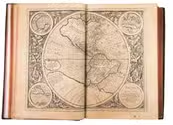
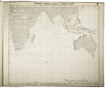
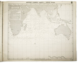
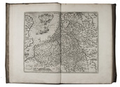
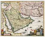
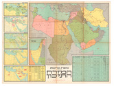
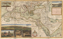
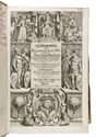
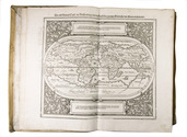
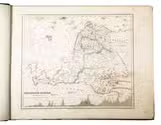
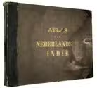
Early atlas of the Dutch East Indies, with 60 large and detailed maps

MELVILL VAN CARNBEE, Pieter and Willem Frederik VERSTEEG. Algemeene atlas van Nederlandsch Indië. Uit officieele bronnen en met goedkeuring van het gouvernement zamengesteld.
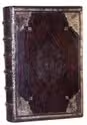
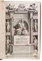
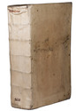
Batavia (Jakarta, Indonesia), Van Haren Noman & Kolff, 1853-1862. Oblong folio (39.3 x 50.5 cm). With 60 lithographed maps, coloured in outline, and 3 lithographed index maps. Contemporary blind-tooled half black morocco. [68] ll. Full description
€ 1,850
Order Inquire Terms of sale

The first edition of the spectacular Mercator-Hondius atlas, a milestone in cartographic history

MERCATOR, Gerardus and Jodocus HONDIUS (publisher). Atlas sive cosmographicae meditationes de fabrica mundi et fabrica figura. Iam tandem ad finem perductus, quamplurimis aeneis tabulis Hispaniae, Africae, Asiae & Americae auctus ac illustratus à Judoco Hondio. Quibus etiam additae (praeter Mercatoris) dilucidae & accuratae omnium tabularum descriptiones novae, studio et opera Pet. Montani.
Amsterdam, Jodocus Hondius, 1606. Folio. With an engraved title page and 144 mostly double-page maps, each with a signature (E-7T) and with explanatory texts on the recto of the first and on the verso of the second fol. (the text pages on the rectos and versos of the maps are paginated 33-354). Original gold- and blind-tooled calf, re-cased, the original leather pasted to the new boards. With a large blind-tooled centrepiece in a blind-tooled lozenge frame, within a blind-tooled rectangle frame, gold-tooled smaller and larger corner pieces and a gold-tooled floral frame along the edges of the boards, both boards show the same design. Further with the title lettered in gold on the spine, and red edges. [16], 354, [12] pp. [+ 8 + 4 + 4 + 8 = 24 pp. for the indexes]. Full description
€ 125,000
Order Inquire Terms of sale

Field guide for officers during the Mesopotamian campaign (1914-1918), with a folding map

[MESOPOTAMIA]. [Indian Army General Staff]. For official use only. Field notes. Mesopotamia. General staff, India. February 1917.Including: Index to field notes, Mesopotamia, 1917.
Calcutta, Superintended government printing, 1917. Small 8vo. With 1 folding heliozincographed map of "Lower Mesopotamia", with some routes in red, and three folding letterpress tables. Original green cloth. [3], [1], 326(=325), [1]; [1], [1 blank], XX pp. Full description
€ 6,500
Order Inquire Terms of sale

Highly detailed maritime atlas

GREAT BRITAIN METEOROLOGICAL OFFICE. Monthly current charts for the Indian Ocean. From information collated & prepared in the Meteorological Office.
London, Admiralty Hydrographic Office, under the superintendence of Rear-Admiral W. J. L. Wharton, 1895-1896. Plano. Oblong Royal 1mo (full-sheet leaves: 51 x 62 cm). An atlas of 12 large black and white nautical charts. Limp cloth with gold-tooled title on front cover. [12] ll. plus the 1-page “Advertisement”. Full description
€ 3,500
Order Inquire Terms of sale

The first contemporary history of the Netherlands. In the first Latin edition, with a rare portrait of the author

METEREN, Emanuel van. Historia Belgica nostri potissimum temporis Belgii sub quatuor Burgundis & totidem Austriacis principibus coniunctionem & gubernationem breviter. Turbas autem, bella et mutationes tempore regis Philippi, Carli V. Caesaris filii, ad annum usque 1598. plenius complectens, conscripta.
[Cologne, A. Mylius, 1598]. Folio. With letterpress title-page in engraved border with scenes of trade and war (Verduyn, pl. XIV), additional engraved medallion portrait of the author mounted on blank back of title-page, by Hendrik Hondius the Elder, double-page engraved map of the Netherlands, by Frans Hogenberg and 22 engraved portraits on 19 plates. Contemporary vellum. [8], "623" [= 643], [1] pp. Full description
€ 2,000
Order Inquire Terms of sale

Excellent, attractively coloured large map of the Ottoman Empire at its height

MOLL, Herman. The Turkish empire in Europe, Asia and Africa, divided into all its governments, together with the other territories that are tributary to it, as also the dominions of the Emperor of Marocco.
London, Herman Moll, John Bowles, Thomas Bowles & John King, ca. 1730. A large engraved map in two sheets (61 x 101 cm as assembled) at a scale of about 1:7,100,000, with 3 insets containing 6 topographic and architectural views. Coloured. Full description
€ 8,500
Order Inquire Terms of sale

Most extensive edition of a monumental, extensively illustrated description of the world

MÜNSTER, Sebastian. Cosmographia, das ist: Beschreibung der gantzen Welt, ...
Basel, heirs of Sebastian Henricpetri, 1628. Folio (38 x 24.5 cm). With engraved title-page, letterpress title-page printed in red and black with woodcut portrait of Münster on the back, 26 numbered double-page woodcut maps on inserted bifolia, 72 double-page woodcut maps, plans and views on integral leaves, and about 1500 woodcut illustrations in the text (including repeats) showing maps, plans, views, plants, animals, monsters, etc. Contemporary vellum. [24], “1752” [=1748] , [12] pp. Full description
€ 48,000
Order Inquire Terms of sale

For official use only: Royal Navy wartime handbook on Iraq and the Persian Gulf

NAVAL INTELLIGENCE DIVISION. [MASON, Kenneth, a.o.]. Iraq and the Persian Gulf. September 1944. B.R. 524 (restricted) geographical handbook series for official use only.
[Oxford,] Naval Intelligence division, 1944. 8vo. With numerous diagrams, reproductions of photographs and (folding) maps, including a loose map in the pocket at the back. Publisher's green cloth. 682 pp. Full description
€ 3,500
Order Inquire Terms of sale
173 books found / Show all