Categories
Shopping cart (0 items € 0)
Advanced search

Cartography, Exploration & Voyages / Atlases, Charts, Maps & Globes

Fascinating and thrilling account of the land survey work in Palestine in the 1870s.

CONDER, Claude Reignier. Tent work in Palestine. A record of discovery and adventure.
London, Richard Bentley & Son, New Burlington Street, 1879, 2 vols., Many half- and some full-page Illustrations and maps throughout. Contemporary green morocco, with gold-tooling to boards and spine. XXVI, 381, [1]; VII, 352 pp. Full description
€ 500
Order Inquire Terms of sale

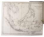
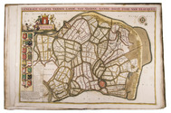
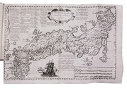
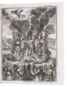
Only Portuguese edition of Crasset's history of the Jesuits in Japan, the only edition with a map of Japan

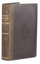
CRASSET, Jean and Maria Antonia de Saõ Boaventura MENEZES (translator). Historia da Igreja do Japaõ, . . .
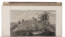
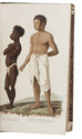
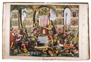
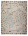
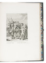
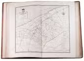
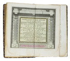
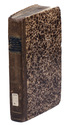
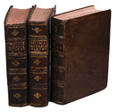
Lisbon, Manoel da Sylva (vols. 1-2), Manoel Soares (vol. 3), 1749-1751. 3 volumes. 4to. With 5 folding engraved plates, 1 folding engraved map of Japan (28×42 cm) and 1 engraved illustration in the text. Contemporary tanned sheepkin, gold-tooled spines. Full description
€ 9,000
Order Inquire Terms of sale

Much acclaimed work on the Indonesian Archipelago

CRAWFURD, John. De Indische Archipel, in het bijzonder het eiland Java.
Haarlem, widow A. Loosjes (colophon: Amsterdam, printed by H. Bakels), 1823-1825. 3 volumes. 8vo. With 3 line-etched frontispieces, 3 full-page plates (2 line-etched, 1 hand-coloured aquatint with line etching), and a folding map (44 x 55.5 cm), hand-coloured in outline. Contemporary mottled half calf, gold-tooled spine. XXII, 332, [2]; LXXII [= LXXIV], 434, [1], [1 blank]; LX, 538, [2] pp. Full description
€ 2,500
Order Inquire Terms of sale

John Crawfurd's sequel to his History of the Indian Archipelago

CRAWFURD, John. A descriptive dictionary of the Indian Islands & adjacent countries.
London, Bradbury & Evans, 1856. 8vo. With a folding engraved map of parts of the East Indies and Southeast Asia, with title "Asiatic Archipelago". Original publisher's blind-blocked brown cloth, title in gold on spine. [4], 459, [1 blank] pp. Full description
€ 2,750
Order Inquire Terms of sale

Beautiful atlas of the Land van Voorne, in full contemporary colour

DIJCK (DYCK), Heyman van. Voorne caart-boeck van alle de dorpen, en polders gelegen inden lande van Oost, ende West Voorne, mitsgaders over Flacquée.
[Netherlands, ca. 1701]. Imperial folio (ca. 55 x 38 cm). Etched double-page title-page by Romeyn de Hooghe, dated "1701", and 32 engraved double-page maps (numbered I- VI, A-F and 1-9) engraved by Jan Stemmers and etched by Jan and Caspar Luyken after drawings by A. Steyaart, all in beautiful contemporary colouring. Contemporary red half sheepskin. Full description
€ 25,000
Order Inquire Terms of sale

Highly decorative celestial chart, coloured by a contemporary hand

DOPPELMAYR, Johann Gabriel. Hemisphaerium coeli boreale in quo fixarum loca secundum eclipticae ductum ad an[n]um 1730 completum exhibentur.
[Nürnberg, Heirs of Homann, 1742]. Engraved celestial chart (50 x 59 cm), wholly coloured by a contemporary hand. With title at the head, circular chart in the centre flanked by positional tables and views of the astronomical observatories of Tycho Brahe at Hven, at Paris, of Hevelius at Danzig and of Eimmart at Nürnberg. Framed (69 x 77 cm). Full description
€ 1,750
Order Inquire Terms of sale

Beautiful hand-coloured wall map of Rijnland

DOU, Jan Jansz. (Johannes Dou I), Steven van BROECKHUYSEN and Melchior BOLSTRA. 'T Hooge Heemraedschap van Rhynland.
[Amsterdam], Isaak Tirion, 1746. Atlas folio (58.5 x 37.3 cm). With 15 double-page engraved plates, all coloured by hand, including 13 maps. The plate size is mostly ca. 44.5 x 55 cm and ca. 41.5 x 55 cm, the map of the Haarlemmermeer has plate size 55 x 63 cm. An illustration of existing and projected sluices for drainage of the polder and another illustration with title, both after drawings by Melchior bolstra. All plates mounted on stubs so that they open flat. Half red sheepskin and intricately marbled paper sides. Full description
€ 6,000
Order Inquire Terms of sale

Detailed account of a commercial expedition to Senegal and Sierra-Leone, attractive copy with 18 engraved plates and 16 maps

DURAND, Jean-Baptiste-Léonard. Voyage au Sénégal, ou mémoires historiques, philosophiques et politiques sur les découvertes, les établissemens et le commerce des Européens dans les mers de l'Océan Atlantique, depuis le Cap-Blanc jusqu'à la rivière de Serre-Lionne inclusivement; suivis de la relation d'un voyage par terre de l'île Saint-Louis à Galam, et du texte arabe de trois traités de commerce faits par l'auteur avec les princes de pays.
Paris, Henri Agasse, 1802. 2 volumes (1 text and 1 atlas). 4to. Atlas with an engraved portrait of Léonard Durand, 16 double-page engraved maps (mostly folding) and 27 engraved plates. Modern dark green half morocco, gold-tooled spine, upper edges gilt. [4], XXXII, 420; VIII, [4], 68 [1 blank] pp. Full description
€ 6,500
Order Inquire Terms of sale

First and only edition of a detailed and accurate atlas of Friesland

EEKHOFF, Wopke. Nieuwe atlas van de provincie Friesland, bevattende kaarten van de dertig grietenijen of gemeenten, met de daarin gelegene elf steden en haar grondgebied, alsmede van de eilanden Ameland en Schiermonnikoog.
Leeuwarden, W. Eekhoff, 1849-1859. Large folio (68 x 41 cm). With 32 large double-page maps, of which 2 folding, engraved by D. & H. Veelwaard after J.W. Witteveen. Further with the engraved coat of arms of the Province of Friesland on the title page. Contemporary half brown morocco and pebble-grained brown cloth sides. [4] pp. + 32 maps. Full description
€ 2,500
Order Inquire Terms of sale
173 books found / Show all