Categories
Shopping cart (0 items € 0)
Advanced search

Cartography, Exploration & Voyages / Geography, Topography & Views

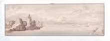
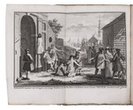
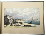
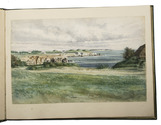
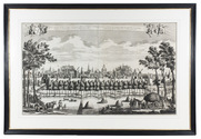
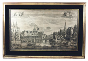
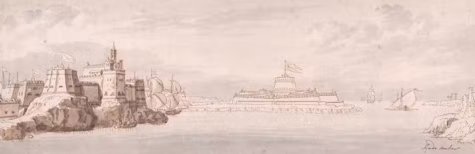
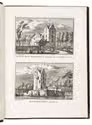
Beautiful views of castles, ruins, monasteries, villages and towns of the Dutch Republic

RADEMAKER, Abraham. 
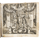
Kabinet van Nederlandsche en Kleefsche outheden.
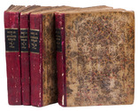
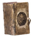
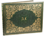
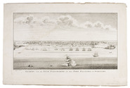
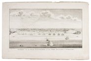
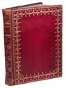
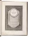
Amsterdam, Isaak Tirion, [between 1728 and 1766]. 2 parts in 1 volume. 4to. With an engraved title page in each part, and 300 numbered engraved half-page views. Contemporary gold-tooled red morocco. [76]; [76] ll. Full description
€ 3,500
Order Inquire Terms of sale

Splendid ink and colour wash view of Valetta in Malta

[MALTA]. RADEMAKER, [Gerard?]. Malta. [View of the castle, fortifications and harbour of Valetta].
[Malta(?), ca. 1700?]. 14 x 44 cm. Ink and colour wash drawing, signed in the lower right corner: "Rademaker". Mounted in a rice-paper window kept under passe-partout. Full description
€ 12,500
Order Inquire Terms of sale

Rare description of Russia just after the Turkish war,
with a revised version of the first map of the entire Russian Empire

REITZ, Johann Frederik, and others. Oude en nieuwe staat van't Russische of Moskovische Keizerryk, behelzende eene uitvoerige historie van Rusland en deszelfs groot-vorsten; benevens de beschryvinge van dat uitgestrekte ryk, de zeden en godsdienst der inwoneren: zyne opkomst en voortgang in koophandel, kunsten, land- en zeemacht, oproeren, oorlogen en verdere wisselvalligheden, tot dezen tegenwoordigen tydt toe.
Utrecht, Johannes Broedelet, 1744. 4 volumes. 4to. With 4 folding maps, 3 folding plates and a folding letterpress table. Early 19th-century half red sheepskin. [2], 296; [2], 200, 200a-200d; [2], 501; [2], 830 pp. Full description
€ 4,250
Order Inquire Terms of sale

The Low Countries: a geographical and historical description in German,
fitting in the publishing programme of the firm of Christoph Riegel in Frankfurt am Main

[RIEGEL, Christoph]. Ausführliche und grundrichtige Beschreibung der freyvereinigten Staaten und Spannischen Niederlanden, in gewisse und sonderbare XVII. Länder abgetheilet ...
Frankfurt am Main and Leipzig, Christoph Riegel, 1691. 12mo. With a folding engraved frontispiece, 61 full-page engraved plans, and 59 full-page engraved views of the cities and fortifications of the Low Countries. Contemporary vellum with an oval supralibros mounted in the centre of both boards, red edges, leather closing ties. [8], 1078, [8] pp. + 120 engravings. Full description
€ 2,500
Order Inquire Terms of sale

22 excellent watercolour views of rocky sea-coasts in New Caledonia & Peru

ROMIEUX, Osmond. [Watercolour views of sea-coasts in New Caledonia and Peru].
[New Caledonia & Peru], [1855/60?]. Album: full-sheet leaves (oblong 1mo) (39.5 × 52.5); drawings: oblong folio and oblong 4to. An album with 21 watercolour drawings on paper with views of sea coasts from the shore (24 × 31 cm to 29.5 × 46.5 cm), one with a 22nd watercolour drawing on the back with a similar view, and one with about 15 human figure drawings in graphite pencil on the back. All bear the artists stamp on the front (Lugt 3703) and 4 are signed or initialled by the artist. Richly gold- and blind-tooled green goatskin morocco, white watered silk endleaves. 21 album ll. with 1 drawing mounted on each recto. Full description
€ 18,000
Order Inquire Terms of sale

Beautiful 18th-century view of Leiden

[VIEW - NETHERLANDS - LEIDEN]. SCHENK, Leonardus [and Abraham RADEMAKER]. Gesigt van de stadt Leyden beroemt door syn hooge schoole geleege in Holland op den verstopten Ryn. | Vue de la ville de Leide fameuse par son academie située en Hollande sur le Rhin bouché.
[Amsterdam], Leonardus Schenk, [ca. 1728/36]. Large engraved wall print on 2 sheets (together 57.5 x 97 cm) showing the Leiden city wall between the Koepoort and Zijlpoort, with various windmills and prominent buildings in the background identified by name. The title appears in a banderole at the head, with putti on either side holding the arms of Leiden and Holland. Leonardus Schenk's name appears as engraver and publisher at the right end of the banderole. Framed (82.5 x 121 cm). Full description
€ 8,500
Order Inquire Terms of sale

Magnificent 18th-century view Leiden's trade and commerce centre

[VIEW - NETHERLANDS - LEIDEN]. SCHENK, Leonardus [and Abraham RADEMAKER]. Gesigt van de Visbrug, de Waag en Vismarkt, te sien naar de Hooglandsche kerk en Stadhuys tooren, tot Lyden. | Vüe du Visbrug, du Pois et Poissonerie, vers l'eglise de Hooglande et la tour de la Maison de Ville a Leide.
[Amsterdam], Leonardus Schenk, [ca. 1728/35]. Large engraved wall print on 2 sheets, (together 58 x 97 cm) the sheets overlapping each other slightly, showing the traditional business centre of the city of Leiden. The title, both in Dutch and French, is printed in a banderole at the head, with putti on each side supporting the arms of Leiden and Holland. Leonardus Schenk's name appears as engraver and publisher at the right tip of the banderole. In black passepartout and gilt frame (82 x 121 cm). Full description
€ 8,500
Order Inquire Terms of sale

Contemporary illustrations of the Trollhätte Canal

SKJÖLDEBRAND, Anders Frederik. Description des cataractes et du canal de Trollhätta en Suède; avec un précis historique.
Stockholm, Charles Delén, 1804. 4to. With an aquatint title-page and 12 aquatint plates, including 1 map, all drawn and engraved by the author. Contemporary grey-blue wrappers. [1], [1 blank], 47, [2] pp. Full description
€ 850
Order Inquire Terms of sale

Finely executed Royal Naval Academy exercises by the teenage future Admiral,
Charles Sotheby 493 pages including nautical charts, fortification plans,
astronomical diagrams, topographic views, etc.

SOTHEBY, Charles. [Engraved title page:] A plan of mathematical learning taught in the Royal Academy Portsmouth performed by [in pencil: Charles Sotheby] a student there.
[Portsmouth], "177 " [recté 1795-1798]. 2 volumes. Imperial 4to (37.5 x 27 cm). Manuscript school exercises with a pre-printed engraved title-page with a blank space for the student to add his name, with 4 full-page and 1 larger folding nautical charts (some partly in colour), 7 full-page fortification plans (in black ink with 1 to 3 colours), 4 full-page astronomical diagrams (2 also with yellow), a full-page compass rose, 23 pen and ink wash views in the text (9 x 15 cm to 12.5 x 22 cm, 1 also with blue washes), and numerous other diagrams (including maps in the surveying section) and some illustrations in the text. Near contemporary (ca. 1803) blind- and gold-tooled half calf, blue sprinkled edges. Engraved title page + “229” [= 228]; 230-493, [2 blank] pp., with pp. 229 and 493 blank excepting the page numbers. Full description
€ 25,000
Order Inquire Terms of sale
106 books found / Show all