Categories
Shopping cart (0 items € 0)
Advanced search

Europe / Cartography, Exploration, Travel & Voyages

First English edition of Varthema’s travels in the Middle East and beyond

[VARTHEMA, Ludovico di, Pietro Martire d’ANGHIERA and others]. 
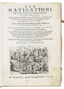
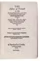
The history of travayle in the West and East Indies, ...
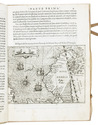
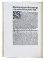
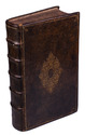
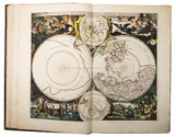
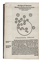
London, Richard Jugge, 1577. Narrow 4to (19 x 13.5 cm). With a woodcut celestial map of the South Polar sky in the text. With 14 leaves in a 19th-century facsimile. Gold- and blind-tooled maroon morocco (ca. 1860?), in allusive style. In a modern clam-shell box. [10], 466, [6] ll. Full description
€ 120,000
Order Inquire Terms of sale

In search of a northeast passage

VEER, Gerrit de. Tre navigationi fatte dagli Olandesi, e Zelandesi al settentrione nella Norvegia, Moscovia, e Tartaria verso il Catai, e regno de' Sini, doue scopersero il Mare di Veygatz, la Nuova Zembla.
Venice, Giovanni Battista Ciotti, 1599. 4to. With an engraved plate on title-page, full-page engraving of a compass and 31 half-page engraved maps and plates in text. Later vellum. [4] 79 ll. Full description
€ 8,500
Order Inquire Terms of sale

In search of a northeast passage

VEER, Gerrit de (et al.). Verhael van de eerste schip-vaert der Hollandische ende Zeeusche schepen door 't Way-gat, by Noorden Noorwegen, Moscovien ende Tartarien, na de coninckrijcken Cathay ende China. Met drie schepen, uyt Texel gezeylt in den jare 1594. Hier achter is by-ghevoeght de beschrijvinghe van de landen Siberien, Samoyeda, ende Tingoesa. Seer vreemt en vermaackelijck om lesen.
Amsterdam, for Joost Hartgers, 1648. 4to. With woodcut illustration on title-page and a double-page engraved plate with 6 illustrations. Old marbled wrappers. [2], 57, [1 blank] pp. Full description
€ 3,950
Order Inquire Terms of sale

Early photographic facsimile of Amerigo Vespucci's report, one of 10 copies printed on vellum

VESPUCCI, Amerigo. Be [! = De] ora Antarctica per regem Portugallie pridem inventa.
[Paris, Tross, 1872]. Facsimile of the 1505 edition with 1 diagram constructed from rules and type. Printed on vellum. Wrapper made from 18th-century French marbled paper backed with (and the book interleaved with) 19th-century wove paper. [11], [1 blank] pp. plus interleaving. Full description
€ 4,500
Order Inquire Terms of sale

A rare and magnificent 18th-century portolan chart of the Portuguese Empire,
produced at the time of the Atlantic slave trade

VIANNA, Manoel José. [Manuscript portolan chart of the Atlantic Ocean, including Western Europe, South America, and West Africa].
Porto, 1786. Chart ca. 86 x 68 cm; frame ca. 101 x 83.5 cm. Detailed manuscript portolan chart in ink and paint and/or ink wash in green, yellow, red, and brown on vellum. The chart is drawn within a red washed border and shows the detailed coastlines of the east coast of South America, the west coast of Africa, and the west coast of northwest Europe up to the Netherlands and including Great Britain and Ireland. The coasts are drawn in sections alternatingly in yellow, green, and red ink. Principal regions are added in large decorative script, coastal towns, cities, and capes are added in a small cursive hand. Also depicted are a detailed split graticule indicating longitude and latitude, intricate rhumb lines, islands, dangerous rocky outcrops (marked vegia (= vigia, meaning lookouts)), and inshore shoals. Further decorative elements in the chart are the flags in Brazil (Portuguese coat-of-arms), Algeria (Ottoman Empire?), and West Africa (Dutch flag, upside down); the side view of Elmina Castle in west Africa, two half wind roses, elaborate rococo floral (fleur-de-lis) ornaments at the head of the chart and in South America. The banderole at the bottom of the chart contains the following text: "Manoel Joze Vianna a Fes no Porto" and below the year of production "1786". Framed in a gold-coloured frame and mounted on a cream cloth covered backboard. Full description
€ 135,000
Order Inquire Terms of sale

The other way around: North America and Europe seen through the eyes of a Chilean historian

VICUÑA MACKENNA, Benjamin. Pájinas de mi diario durante tres años de viajes. 1853. - 1854. - 1855. ... California. - Mejiico. - Estados-Unídos. - Canada. - Islas Britanicas. - Francia. - Italia. - Alemania. - Paises-Bajos. - Costas del Brasil. - Provincias del Plata.
Santiago, Imprenta del Ferrocarril, 1856. 4to. Contemporary half green sheepskin, marbled edges. [8], 454 pp. Full description
€ 4,950
Order Inquire Terms of sale

The Siberian prison camps in the 18th century and the rights of a people living under occupation

WAGNER, Johann Ludwig. Mémoires de M. Wagner, sur la Russie, la Sibérie et le royaume de Cassan.
Bern, Emanuel Haller, 1790. 8vo. With an engraved portrait of the author and 2 engraved plates. Contemporary boards covered with sprinkled paper, paper title label on spine. [4], 254, [2 blank] pp. Full description
€ 750
Order Inquire Terms of sale

The travel adventures of a famous book and art collector

WILLIGEN, Adriaan van der. Aanteekeningen op eene reize van Parijs naar Napels, door het Tirolsche en van daar door Zwitserland en langs den Rhijn terug naar Holland.
Haarlem, Adriaan Loosjes, (back of half-title parts 2-4: Utrecht, G. Post), 1811-1813. 4 parts in 2 volumes. Large 8vo. With an engraved title-page to the first part (with a stipple-engraved medallion portrait of the author) and 13 engraved plates by J. P. Visscher Bender. Contemporary half calf, gold-tooled spines. VIII, 269, [1]; IV, 292; VIII, 322; "VIII"[=6], 405, [3] pp. Full description
€ 4,000
Order Inquire Terms of sale

A nicely coloured history and description of Friesland: presentation copy by the author

WINSEMIUS, Pierius. Chronique ofte historische geschiedenisse van Vrieslant. Beginnende vanden jaere nae des Werelts scheppinghe 3635. ende loopende tot den jaere nae de gheboorte Christi.
Franeker, Jan Lamrinck, 1622. Folio. With an engraved allegorical title page, a large engraved coat of arms of the province of Friesland, a large folding engraved map of Friesland, 3 folding engraved plans. Further with (in the text) 49 half-page, full-length engraved portraits, 2 engraved costume plates, 2 plans of sieges, 1 view 6 seals and coats of arms of Friesland at the end. Also with many woodcut decorated initials and woodcut head- and tailpieces. All engraved and woodcut illustrations are beautifully coloured by a contemporary hand. Contemporary gold-tooled sprinkled calf. [10], 913, [61] pp. Full description
€ 32,500
Order Inquire Terms of sale

Extremely rare atlas with 76 very large hand-coloured maps

WIT, Frederick de. Atlas maior.
Amsterdam, Johannes Covens & Cornelis Mortier, [ca. 1725]. Imperial folio (53 x 35.5 cm). With engraved title-page and 76 double page (or in 8 cases larger folding) engraved maps, the title-page and all maps and their decorations coloured by a contemporary hand. Half tanned sheepskin (ca. 1900), gold-tooled spine. Full description
€ 45,000
Order Inquire Terms of sale
131 books found / Show all