Categories
Shopping cart (0 items € 0)
Advanced search

Europe / Cartography, Exploration, Travel & Voyages

The first German edition of Boswell's Account of Corsica with a folding map

BOSWELL, James. Beschreibung von Corsica nebst vielen wichtigen Nachrichten und Anecdoten vom Pascal Paoli dem General der Corsen.
Leipzig, Caspar Fritsch, 1768. 2 parts in 1 volume. 8vo. With an engraved folding map of Corsica (29 x 44 cm). Contemporary paper-covered boards, spine with red title label lettered in gold, red edges. [14], 346 pp. Full description
€ 1,875
Order Inquire Terms of sale

Quixotic adventures in Corsica
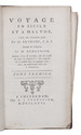
BOSWELL, James. 
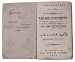
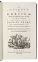
An account of Corsica, the journal of a tour to that island; and memoirs of Pascal Paoli.
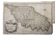
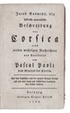
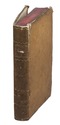
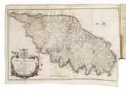
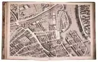
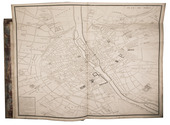
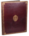
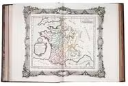
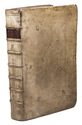
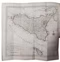
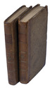
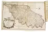
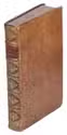
Glasgow, printed by Robert & Andrew Foulis for Edward & Charles Dilly London, 1768. 8vo (ca. 21 x 13 cm). With an engraved vignette on the title page incorporating the crowned coat of arms of the Republic of Corsica, and a large folding map (plate size 27.5 x 45 cm) of Corsica engraved in Edinburgh by Thomas Phinn in 1768. Contemporary calf, rebacked with the original backstrip, with the red morocco title label lettered in gold, laid down. XXI, [1 blank], [1], [1 blank], 382 pp. Full description
€ 2,000
Order Inquire Terms of sale

Fine untrimmed copy of a pilot guide, with coloured maps and aquatint profiles

BOUGARD, René and John Thomas SERRES. The little sea torch: or, true guide for coasting pilots.
London, J. Debrett for the "author" [Serres], G. & W. Nicol, et al. [printed by T. Rickaby], 1801. Large folio (47 x 30 cm). With 20 numbered aquatint plates containing 137 coastal profiles, and 12 partly numbered engraved plates containing 24 maps of port cities, harbours, islands and the Strait of Gibraltar. All coastal profiles and maps beautifully and subtly coloured by a contemporary hand. Contemporary boards. VI, 144, [5] pp. Full description
€ 14,500
Order Inquire Terms of sale

A Dutch view on the military campaigns of Napoleon

BOYMANS, Johannes Andreas. Le garde d'honneur, ou episode du règne de Napoléon Buonaparte.
Bruxelles, Weissenbruch, 1822. 8vo. With 2 large folding maps after designs by G.F. Baron de Derfelden de Hinderstein, partly coloured by hand, a white on black phantasmagoric folding lithographed plate, and 4 folding lithographed views by Kierdorff after E. van Boeckhoven. Later gold-and blind tooled half green calf, with the author and title lettered in gold on the spine, green decorative paper sides, green decorative paper end papers. XXXIV, 69, XLI, XVIII, [2], [1 blank] pp. Full description
€ 1,600
Order Inquire Terms of sale

The greatest map of Paris, 240 x 316 cm, here with the 20 sheets and key map bound as an atlas
in contemporary gold-tooled morocco with the Paris city arms

BRETEZ, Louis. Plan de Paris commencé l'année 1734. Dessiné et gravé, sous les ordres de Messire Michel Etienne Turgot, Marquis de Sousmons ... Achevé de graver en 1739.
[Paris, 1739]. Grand-Aigle folio (56 x 45.5 cm). An enormous engraved map of Paris in 20 numbered sheets plus a key map, at a scale of about 1:2000, each segment measuring 55 x 84 cm (plate size 51.5 x 80.5 cm; image 48 x 79 cm) which would give an assembled map with image size about 240 x 316 cm! The key map is slightly larger than the segments and folds out at the head. Bound as an atlas (but with segments 18 and 19, containing the cartouche, assembled to make a long fold-out) in contemporary gold-tooled red morocco, each board with as centrepiece the Paris coat of arms (a ship with chief a field of fleurs-de-lis). Full description
€ 15,000
Order Inquire Terms of sale

France elaborately mapped: a famous and rare atlas including key maps for travellers

BRION DE LA TOUR, Louis & Louis Charles DESNOS. Coup d'oeil général sur la France, pour servir d'introduction au tableau analytique et géographique de ce Royaume. Dressé par différens géographes, dont les ouvrages sont aussi connus qu'estimés, faisant partie de l'atlas historique de la France ancienne & moderne ...
Paris, Grangé, Guillyn, Desnos, et al., 1765. 2 works in 1 volume, the first in 3 parts. 4to. With a double-page frontispiece by Le Charpentier after De Sève, with a view of the Place de la Concorde in Paris, 2 large folding engraved maps of France by Rizzi Zannoni, 40 double-page engraved maps and charts of France, 10 folding road maps, 2 "Cartes odographiques" with the distances between French cities, and 3 double-page engraved part-titles, all but the frontispiece and titles in a contemporary hand colouring.
Comprising: (2) DESNOS, Louis Charles. Tableau analytique de la France.
Paris, chez l'auteur, 1765.
(3) ZANNONINI, Rizzi. Le petite Neptune François ou carte des côtes maritimes du Royaume.
Paris, chez le Sr. Desnos, 1765.
(4) MICHEL. L'indicateur fidèle ou guide des voyageurs.
Paris, à l'enseigne du globe, 1765.
With: (5) [CATALOGUE]. Catalogue des Ouvrages, tant anciens que modernes, du Fonds du Sr. Desnos.
Paris, à l'enseigne du globe et de la sphere, 1765. Contemporary gold- and blind-tooled marbled calf. 15, [1 blank], [3], [1 blank], 8, 10; 16 pp. + 56 plates Full description
€ 3,250
Order Inquire Terms of sale

First edition of a sumptuous account of a voyage to Russia, Persia and the East Indies,
with large folding views of Moscow and Isfahan (194x42 cm)

BRUYN (LE BRUN), Cornelis de. Reizen over Moskovie, door Persie en Indie: verrykt met driehondert konstplaten, vertoonende de beroemste lantschappen en steden, ook de byzondere dragten, beesten, gewassen en platen, die daer gevonden worden ...
Amsterdam, Willem and David Goeree for the author, 1711. Folio (40x25.5 cm). With engraved frontispiece by Bernard Picart, engraved author's portrait, 2 folding engraved maps, 109 engraved plates (13 folding, 55 double-page, 41 full-page) and 36 engraved illustrations in text. Contemporary blind-tooled vellum. [8], 472, [12] pp. Full description
€ 9,000
Order Inquire Terms of sale
131 books found / Show all