Categories
Shopping cart (0 items € 0)
Advanced search

Middle East & Islamic World / Central & West Asia

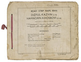
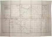
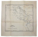
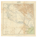
Ottoman map of Iraq, Kuwait and southwestern Iran, used by its army in World War I

[MAP - OTTOMAN ARMY]. [Iraq, Kuwait and Iran].
Istanbul, [Erkan-i Harbiye-i Umumiye], 1331 Rumi [= 1915 CE]. Colour-lithographed map of Iraq, Kuwait and southwestern Iran (65.5 x 66 cm) in black, brown, blue and green at a scale of 1:1,000,000, dissected into 12 sections and mounted on contemporary cloth. Full description
€ 3,500
Order Inquire Terms of sale

Only known copy of military road maps of the Persian Corridor

[MAPS - IRAN - WWII]. Road strip maps Iran. Dizful-Kazvin (1-10), Hamadan-Khosrovi (11-16).
"83 Rep Group. I.E.", July 1944. Oblong (21 x 25,5 cm). With 1 index map and 16 numbered folding strip maps. Original beige printed paper wrappers, side stichted (by hand) through 3 holes with a reddish pink cloth ribbon. [17] ll. Full description
€ 3,500
Order Inquire Terms of sale

Photo album with 250 images of Egypt, Palestine, Syria, Iran and Iraq,
compiled by a member of Paiforce in the 1940s

MEKELBURG, Corporal George (compiler). [Album of 250 photographs of the Middle East].
[Habbinya?, ca. 1944]. Ca. 20 x 16 cm. With 250 gelatin silver prints (various sizes), mounted on the leaves of a ruled notebook. Contemporary quarter black cloth, blue waterered paper sides, blue sprinkled edges. [85] ll. Full description
€ 2,000
Order Inquire Terms of sale

Field guide for officers during the Mesopotamian campaign (1914-1918), with a folding map

[MESOPOTAMIA]. [Indian Army General Staff]. For official use only. Field notes. Mesopotamia. General staff, India. February 1917.Including: Index to field notes, Mesopotamia, 1917.
Calcutta, Superintended government printing, 1917. Small 8vo. With 1 folding heliozincographed map of "Lower Mesopotamia", with some routes in red, and three folding letterpress tables. Original green cloth. [3], [1], 326(=325), [1]; [1], [1 blank], XX pp. Full description
€ 6,500
Order Inquire Terms of sale

"For offical use only": mapping the Mesopotamian battlefields of WWI

[MESOPOTAMIAN CAMPAIGN]. Critical study of the campaign in Mesopotamia up to April 1917. Part II - Maps.
Calcutta, Government of India Press, 1925. 25 (of 26) folding maps, sketches etc., as always lacking the "Explanation of the Method of giving Map Co-ordinates adopted in Chapters XIII and XX". Original tan cloth map-case with original printed label to cover. 25 (of 26) folding ll. Full description
€ 3,500
Order Inquire Terms of sale

Loans by the UK for major infrastructure development in Jordan

MU'AMMAR, Sayid Ya'coub; B.L. STRACHAN. Exchange of notes concerning an interest-free development loan by the government of the United Kingdom of Great Britain and Northern Ireland to the government of the Hashemite Kingdom of Jordan.
London, Her Majestys Stationery Office, 1970. 4to. With the UK coat-of-arms on title-page. Text in English and Arabic in naskh type. Stapled. 8 pp. Full description
€ 450
Order Inquire Terms of sale

One of the limited official copies of the British Allied War Effort
of a geographical handbook on Palestine and Jordan

NAVAL INTELLIGENCE DIVISION. Palestine and Transjordan. Geographical handbook series.
(colophon:) Oxford, University Press, December 1943. 2 parts in 1 volume. Large 8vo. With 1 large folding map stored in a pocket on the back board of the communications of Palestine (air fields and landing grounds, railways, roads and sea plane moorings), 2 other folding maps (geological map of Palestine; map of Haifa Harbour), 1 double-page plan of the church of Holy Sepulchre and 58 other figures in the text. Also with 154 half-tone photographs, inserted on separate leaves and all numbered and captioned. Original publisher's green cloth, gilt-lettering on front board and spine. XV, 621, [1 blank] pp. Full description
€ 1,000
Order Inquire Terms of sale

Rare handbooks of the British naval intelligence division on Arabia, Palestine, and Syria

NAVAL INTELLIGENCE DIVISION. Syria. April 1943.
With:
(2) IDEM. Palestine and Transjordan. December 1943.
(3) IDEM. Western Arabia and the Red Sea. June 1943.
Stationery Office, University Press Oxford, 1943-1946.
3 volumes. Many plates, tables and photographs. Each volume including separate fold-out maps, one in colour. Contemporary green cloth with the title in gold on the front boards and the spines. [2], XVI, 485, [1]; [2], XV, [1], 621, [1]; [2], XIX, [1], 659, [1] pp. Full description
€ 1,750
Order Inquire Terms of sale

For official use only: Royal Navy wartime handbook on Iraq and the Persian Gulf

NAVAL INTELLIGENCE DIVISION. [MASON, Kenneth, a.o.]. Iraq and the Persian Gulf. September 1944. B.R. 524 (restricted) geographical handbook series for official use only.
[Oxford,] Naval Intelligence division, 1944. 8vo. With numerous diagrams, reproductions of photographs and (folding) maps, including a loose map in the pocket at the back. Publisher's green cloth. 682 pp. Full description
€ 3,500
Order Inquire Terms of sale
162 books found / Show all