Categories
Shopping cart (0 items € 0)
Advanced search

Cartography & Exploration

Exploring central China, with a large folding map

GARNIER, Francis. Voyage dans la Chine centrale, Vallée du Yang-Tzu, fait de mai à aout 1873.
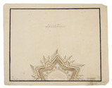
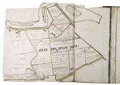
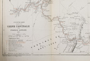
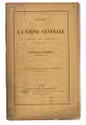
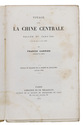
Paris, E. Martinet for Ch. Delagrave, 1874. 8vo. With a large lithographed folding map (26 x 58 cm), with highlights in red, and several letterpress tables. Original publisher's printed yellow wrappers. [3], [1 blank], 39, [1 blank] pp. Full description
€ 1,250
Order Inquire Terms of sale

Rare follow-up to a curious account of the daily life of a French salesman in South America

GENDRIN, Victor-Athanase. Récits historiques, exacts et sincères, des sept voyages par mer & par terre. Faits au Brésil, au Cap-Horn, au Chili, aux Cordillères des Andes, à Mendoza, dans le Désert et à Buénos-Ayres ... Extrait de la publication de 1856.
Versailles, Gendrin (colophon: imprimerie Cerf), 1860. 8vo. With lithographed portrait of the author as frontispiece, 36 (32 numbered followed by 4 unnumbered) pages with lithographed reproductions of letters, and 9 lithographed plates. Contemporary cloth. 24, [4], 32, [4] pp. Full description
€ 2,450
Order Inquire Terms of sale

Three fortification plans, including a large coloured plan of the fortifications of Neuf-Brisach

[DRAWING - FORTIFICATION]. GENNEP, T.P. van. [Three fortification plans].
[Raamsdonk], 1798. 3 manuscript fortification plans (measuring (ad 1) 58 x 93 cm, (ad 2) 24.5 x 24.5 cm (ad 3) 29.5 x 37 cm) on paper. All signed: T.P. van Gennep, 1798; and one: Raamsdonk, 29 January 1798. Full description
€ 950
Order Inquire Terms of sale

The first ethnographic survey of the Russian Empire

GEORGI, Johann Gottlieb. Russland. Beschreibung aller Nationen des russischen Reiches, ihrer Lebensart, Religion, Gebräuche, Wohnungen, Kleidungen und übrigen Merkwürdigkeiten.
Leipzig, Dyk, 1783. 2 volumes. 4to. With 2 etched hand-coloured frontispieces by Schoenberg (coloured by Capieux), and several delicate engraved head- and tailpieces in the text by C.M. Roth. Contemporary half calf, sprinkled boards. [4], XII, [5], [1 blank], 271, [1 blank]; [2], 273-530, [10] pp. Full description
€ 4,500
Order Inquire Terms of sale

Early work on the discovery of the West Indies

GERALDINUS, Alexander. Itinerarium ad regiones sub aequinoctiali plaga constitutas. Opus antiquitates, ritus, mores, & religiones populoru[m], Aethiopie[a], Africae, Atlantici Oceani, Indicarumque regionum complectens.
Rome, Guglielmo Facciotti, 1631. 8vo. With engraved title-page and engraved illustration on the letterpress title-page. Contemporary limp sheepskin parchment. [16], 284, [36] pp. Full description
€ 5,750
Order Inquire Terms of sale

Manuscript atlas and ownership records of parcels in the Prins Willem polder,
northeast of Oostburg, in the southwest corner of the Netherlands

GERSOM, Gerrit van. Caerte en omlooper van Prins Willem Polder. Bedijkt anno 1650 en 1651. ...
[Oostburg?], 1723. Royal folio (41 x 27.5 cm). With a hand-coloured title page, a large folding map of the dikes along the border of the polder, a large folding general map of the polder showing the numbered parcels at a scale of about 1:18,000, and 17 folding detail maps showing the individual plots within the parcels at a larger scale, all executed in brown ink and watercolours and tipped onto the fore-edges of 19 of the 144 numbered text leaves. Contemporary sheepskin parchment. 151 ll. (ll. 1 & 145-151 blank). Full description
€ 9,500
Order Inquire Terms of sale

A general in the Spanish army on the battles and sieges in Flanders 1601-1609,
during the Dutch war for independence, with 29 folding maps and plans

GIUSTINIANO, Pompeo. Delle guerre di Flandra libri VI. ... Posti in luce da Gioseppe Gamurini ...
Antwerp, J. Trognesio, 1609. 4to. With engraved architectural title-page and 29 folding engraved maps and plans of sieges and fortifications. White sheepskin (ca. 1700 or possibly later). [4], 329, [1 blank], [15], [3 blank] pp. Full description
€ 2,950
Order Inquire Terms of sale

Rare collection of travel accounts in the form of letters,
including a Swedish translation of a biography of Captain Cook

GJÖRWELL, Carl Christoffer (ed.). Almänna rese-beskrifwaren eller sammandrag af de nyaste och bästa rese-beskrifningar, hälst de som nyligast utkommit; til uplysning af andra länders geographie, natural-historia, stats-förfatning, hushålning, lärdom, bruk och seder: uti bref författat.
Stockholm, printed by Johan Arvid Carlbohm [and A.J. Nordstrom], 1780 [-1782]. 2 volumes. 8vo. With an engraved portrait of "Jacob" (James) Cook as a frontispiece in vol. 1, with some head and tail pieces throughout the 2 vols. Contemporary half goatskin. [4], 360; [2], 134, [2], 135-194, [2], 195-“168” [= 268] pp. Full description
€ 2,250
Order Inquire Terms of sale

A pair of striking Victorian library globes by map-maker George Frederick Cruchley

[GLOBES - TERRESTRIAL & CELESTIAL]. CRUCHLEY, George Frederick. Cruchley's new terrestrial globe from the most recent and best authorities, exhibiting the discoveries in equatorial Africa, North Pole, and the new settlements and divisions in Australia, New Zealand, California, Texas &c.
London, George Frederick Cruchley, [ca. 1850].
With: CRUCHLEY, George Frederick. Cruchleys new celestial globe on which is accurately laid down the whole of the stars and nebule contained in the astronomical catalogue of the Reverend Mr. Wollaston F.R.S. Also from the authorities Flamstead, De la Caille, Hevellus, Bradley, Herschel, Maskelyne, &c. and the limits of each constellation determined by a boundary line.
London, George Frederick Cruchley, [ca. 1850].
A matching pair of terrestrial and celestial globes (53 cm diameter) each made a hollow paper-marché core (2 hemispheres, joined at the equator), covered with a layer of plaster and 12 hand-coloured, engraved gores, showing the terrestrial geography and celestial bodies in great detail. Each globe mounted in a mahogany tripod stand on small wheels. With a compass (diameter: 25 cm) at the base of each stand; graduated brass meridian ring and engraved graduated horizontal rings (paper pasted on the mahogany frame) showing the months of the year, the zodiac signs and wind directions. Full description
€ 97,500
Order Inquire Terms of sale

First edition of Godinho's important account of his journey through India and the Middle East

GODINHO, Manuel. Relação do novo caminho que fez por terra, e mar, vindo da India para Portugal no anno de 1663.
Lisbon, Henrique Valente de Oliveira, 1665. 4to (19.5 x 14.5). With an engraved coat of arms of the dedicatee Luís de Vasconcelos e Sousa (1636-1720), 3rd Count of Castelo Melhor, at the head of the dedication, and with numerous woodcut decorated initials. 20th-century gold-tooled sprinkled brown calf, bound by the Lisbon bookbinder Frederico de Almeida. [1], [1 blank], [10], 188 pp. Full description
€ 25,000
Order Inquire Terms of sale
711 books found / Show all