Categories
Shopping cart (0 items € 0)
Advanced search

Cartography & Exploration

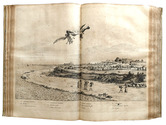
Rare account of a journey to the Leti Islands with beautiful descriptions of the local people and nature

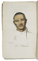
BARCHEWITZ, Ernst Christoph. 
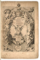
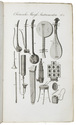
Neu-vermehrte Ost-Indianische Reise-Beschreibung, darinnen I. Seine durch Deutsch- und Holland nach Indien gethane Reise; II. Sein elfjähriger Aufenthalt auf Java ...; III. Seine Rückreise ...
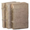
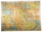
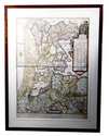
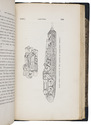
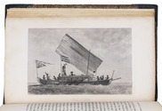
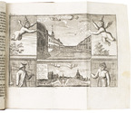
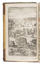
Erfurt, Johann Friedrich Hartung, 1762. 8vo. With an engraved frontispiece, a full-page map, and 6 engraved plates (5 folding, 1 full-page). Later gold-tooled brown half calf. [20], 687, [16] pp. Full description
€ 2,500
Order Inquire Terms of sale

First edition of the magnificent work on the Dutch colony of Brazil,
the folio edition, complete with all plates and maps

BARLAEUS, Caspar. Rerum per Octennium in Brasilia et alibi nuper gestarum.
Amsterdam, Joan Blaeu, 1647. Folio. With an engraved title-page, an engraved portrait of Johan Maurits van Nassau, 25 double-page engraved maps and plans, and 31 double-page engraved plates. Further with a woodcut printer's device on the title-page. Contemporary vellum, upper cover ruled in blind with blind-stamped floral vignette in center. [12, including title-page, frontispiece and portrait], 340, [8] pp. Full description
€ 36,500
Order Inquire Terms of sale

Dutch edition of Barrow's Travels in China

BARROW, John. Reizen in China, ...
Haarlem, François Bohn, 1807-1809. 3 volumes. 8vo. With 10 engraved plates (6 folding, 1 double-page), the double-page plate with 2 portraits hand-coloured, 4 leaves with engraved music, and several woodcut and engraved illustrations in the text. Original publisher's boards. VIII, 288; VI, 334; VI, 341, [1] pp. Full description
€ 950
Order Inquire Terms of sale

Large coloured map of the Middle East, including roads and oil pipe lines

BARTHOLOMEW, John. Middle East with boundaries, roads and railways.
Edinburgh, John Bartholomew & Son, 1962. 8vo. Large folding map (77 x 101 cm) on a scale of 1:4,000,000, linen backed. With relief shown by contours, hachures and gradient tints and depths shown by soundings. Folded, with title-wrapper. Full description
€ 850
Order Inquire Terms of sale

Illustrated edition of Beechey's famous Pacific voyage, including an Eskimo vocabulary

BEECHEY, Frederick William. Narrative of a voyage to the Pacific and Beering's Strait...
London, Henry Colburn & Richard Bentley, 1831. 2 volumes. Large 8vo. With 3 lithographed maps (2 large folding), 20 engraved plates, 3 two-page folding plates, and 1 engraved illustration in the text. Contemporary half green morocco, marbled sides, gold-tooled title on spine, marbled edges. XXVI, [1], [1 blank], 472; IV, 330, [1], 331-452 pp. Full description
€ 1,250
Order Inquire Terms of sale

Very rare map of North Holland in 1575

BEELDSNIJDER, Joost Jansz. Vernieuwde Kaart van Noordholland en Westfriesland, benevens het voornaamste gedeelte van Rhynland, en daar aan grenzende Landen.
Amsterdam, Yntema & Tieboel, 1778. (92 x 68 cm). Large hand-coloured engraved map on 2 sheets, decorated with arms, figures and products from the regions shown, and with the title at the foot. Framed. Full description
€ 7,250
Order Inquire Terms of sale

An important surveying voyage to the Pacific

BELCHER, Edward. Narrative of a voyage round the world, performed in Her Majesty's ship Sulphur, during the years 1836-1842, including details of the naval operations in China, from Dec. 1840 to Nov. 1841.
London, Henry Colburn, 1843. 2 volumes. 8vo. With a folding map of the Canton river, folding map with the routes of the H.M.S. Sulphur, large world chart also showing the route of the Sulphur, 19 steel-engraved views and several illustrations in text. Gold-tooled blue sheepskin, shell-marbled sides. Rebacked. In modern slipcase. XXII, 387; VI, 474 pp. Full description
€ 2,950
Order Inquire Terms of sale
703 books found / Show all