Categories
Shopping cart (0 items € 0)
Advanced search

Cartography & Exploration / Atlases, Charts, Maps & Globes

Rare world atlas with 56 large copper-engraved maps.

L'ISLE, Guillaume de. Atlas nouveau, contenant toutes les parties du monde, ou sont exactement remarquées les empires, monarchies, royaumes, etats, republiques &c.
Including: SANSON, Guillaume. Introduction à la Geographie où sont la geographie astronomique qui explique la correspondance du globe terrestre avec la sphere.
Amsterdam, Johannes Covens and Cornelis Mortier, 1730.
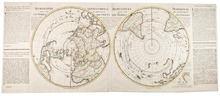
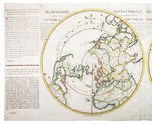
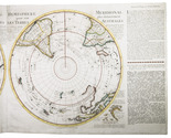
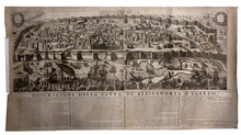
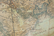
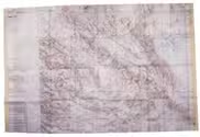
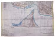
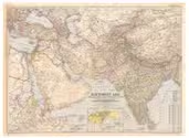
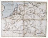
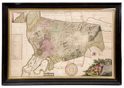
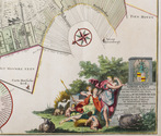
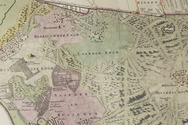
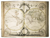
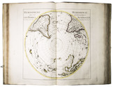
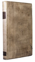
Folio. With a large allegorical frontispiece and 56 large copper-engraved maps (most 54 x 65 cm and a few larger, folding ones). Previous owners have added one large copper-engraved map of Normandie by Jean Baptiste Nolin from 1742, and 2 smaller etchings by Israel Silvestre with views of du Havre and Chateau Jametz. The original artwork of these views is from the 1670s, but these prints are from a later date. Contemporary blind-tooled vellum, green closing ties. [1 blank], [6], 32 pp. Full description
€ 45,000
Order Inquire Terms of sale

De L'Isle's renowned maps of the Northern and Southern hemispheres,
contemporary hand-coloured in outline

L'ISLE, Guillaume de. L'Hemisphere Septentrional pour voir plus distinctement les Terres Arctiques.
Amsterdam, Reinier and Josua Ottens, [ca. 1740 (after 1739)].
Together with: [IDEM]. L'Hemisphere Meridional pour voir plus distinctement les Terres Australes.
Amsterdam, Reinier and Josua Ottens, [after 1739]. 49.5 x 122 cm. Two large hemispherical maps (45 cm in diameter) on two sheets, joined together to make one large oblong world map, with the Dutch and French text of a letter written by a Mr. Swart in St. Petersburg on a separate (partial) sheet joined to the (left) outer edge of the map of the Northern Hemisphere. The map of the Southern Hemisphere includes the short description in Dutch and French of the journey undertaken by the ships Adelaar and Maria to the "Southland" or "Terres Australes" in 1738 and 1739. This description includes the discovery of the Cape Circoncision and a small map of that Cape is included in the bottom right corner of the map of the Southern Hemisphere. The maps are contemporary hand-coloured in outline. Full description
€ 6,500
Order Inquire Terms of sale

Extremely rare example of the largest globe engraved by Malby (45.5 cm diameter), with lines of magnetic variation, London 1848, showing “Debai” (Dubai)

[GLOBE - TERRESTRIAL]. MALBY & CO. Malby's terrestrial globe.
[London], Malby & Co. (engraved by Chas. Malby), 1 January 1848. Diameter: 45.5 cm (18 inch), height in stand: 64.5 cm. An engraved terrestrial globe with 12 gores and 2 polar caps over a plaster-covered core, and the engraved horizon ring on the wooden stand, all coloured by a contemporary hand. In a contemporary wooden stand with 3 turned legs supporting the horizon ring, and 3 turned stretchers with a cylindrical centrepiece with a knob on the underside. Further with a contemporary brass hour circle and a slightly later iron meridian ring (and probably the axis pivots). Full description
€ 35,000
Order Inquire Terms of sale

USAF pilot's map of the Arabian Gulf

[MAP - ARABIAN GULF]. Aeronautical chart and information center. Persian Gulf | ONC-H-6/7. Operational navigation chart.
St Louis, Aeronautical chart and information center, United States Air Force, 1969. Two copies of two folding maps colour printed on both sides of a sheet of silk (103 x 78.5 cm) on a scale of ca. 1:1,000,000. The two maps (ONC-H-6 & ONC-H-7) show one continuous area. Full description
€ 2,800
Order Inquire Terms of sale

Abu Dhabi's Oil industry: the Israeli perspective

[MAP - ARABIAN PENINSULA OIL RESOURCES]. Neft ba-mizrah ha-tikhon. Zikaynot, shadot, tzinorot, batei zikuk. [= Oil in the Middle East. Concessions, oilfields, pipelines, refineries].
Tel Aviv, Israel Defence Forces, General Staff, [1957]. 56 x 82.5 cm. Chromolithographic map of the Arabian Peninsula, from Turkey in the north to the Indian Ocean in the south, and covering Saudi Arabia, Egypt, Israel, Palestine, Jordan, Syria, Lebanon, Iraq, Iran, Kuwait, Bahrain, Qatar, United Arab Emirates, Oman, North and South Yemen. Scale 1:5,000,000. Scale and key in Hebrew inset to top-right, inset explanatory panels in Hebrew and English, compass rose in Saudi Arabia. Folded. Full description
€ 7,500
Order Inquire Terms of sale

Asia and the Middle East in 1952, with many borders on the Arabian Peninsula still undefined

[MAP – ASIA – MIDDLE EAST]. NATIONAL GEOGRAPHIC SOCIETY. Southwest Asia, India, Pakistan, and Northeast Africa.
Washington, DC, National Geographic Society, 1952. Colour printed map, 68.5 x 95 cm. Scale 1:7,5000,000. With an inset map of "the Moslem World; percentage of Moslems in total population". Full description
€ 850
Order Inquire Terms of sale

Engraved map of central Europe, coloured in outline in a contemporary hand

[MAP - CENTRAL EUROPE]. DANCKERTS, Justus. Accuratissima Germaniae tabula.
Amsterdam, Justus Dankerts, [before 1701]. Engraved map (48.5 x 57.5 cm) on a sheet of laid paper (51.5 x 61 cm), coloured in outline in a contemporary hand, with the title in an illustrated cartouche at the upper left, and a scale at the lower right (ca. 1:2,400,000). Full description
€ 450
Order Inquire Terms of sale

Extremely rare travellers map of Northwest Europe indicating the main cities
and post stations and the distances between them

[MAP - FRANCE - GERMANY]. Nouvelle carte itinéraire, qui indique d'une manière très-exacte les routes et stations, ainsi que les distances des principales villes de France et dAllemagne.
Amsterdam, E. Maaskamp, [ca. 1810]. An engraved map printed on linen (ca. 33.5 x 43 cm.), partly coloured by hand in red and blue ink. Folded. Full description
€ 1,750
Order Inquire Terms of sale

Rare wall map of the Gooi, coloured by a contemporary hand

[MAP - HET GOOI]. POST, Hendrik. Nieuwe kaart van Gooilandt word met schuldige eerbiedigheidt aan den wel. ed. gestr. Heere en Mr. Henrick Bicker schepen der stadt Amsterdam, raadt en advt. fiscaal ter Admiraliteit aldaar meestersknaap van Gooilandt, enz, enz. opgedragen door Reinier & Josua Ottens.
Amsterdam, Reinier & Josua Ottens. [ca. 1737]. 52.5 x 82 cm. Framed. Full description
€ 28,000
Order Inquire Terms of sale
167 books found / Show all