Categories
Shopping cart (0 items € 0)
Advanced search

Cartography & Exploration / Middle East & Islamic World

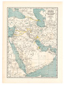
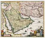
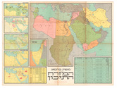
Asia and the Middle East in 1952, with many borders on the Arabian Peninsula still undefined

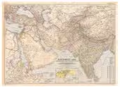
[MAP – ASIA – MIDDLE EAST]. NATIONAL GEOGRAPHIC SOCIETY. 
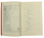
Southwest Asia, India, Pakistan, and Northeast Africa.
Washington, DC, National Geographic Society, 1952. Colour printed map, 68.5 x 95 cm. Scale 1:7,5000,000. With an inset map of "the Moslem World; percentage of Moslems in total population". Full description
€ 850
Order Inquire Terms of sale

"For offical use only": mapping the Mesopotamian battlefields of WWI

[MESOPOTAMIAN CAMPAIGN]. Critical study of the campaign in Mesopotamia up to April 1917. Part II - Maps.
Calcutta, Government of India Press, 1925. 25 (of 26) folding maps, sketches etc., as always lacking the "Explanation of the Method of giving Map Co-ordinates adopted in Chapters XIII and XX". Original tan cloth map-case with original printed label to cover. 25 (of 26) folding ll. Full description
€ 3,500
Order Inquire Terms of sale

The climate of the East African coast

[METEOROLOGICAL OFFICE - EAST AFRICA]. Weather in the Indian Ocean to Latitude 30° S. and Longitude 95° E. Including the Red Sea and Persian Gulf. Volume II. Local information. Part 9 Coast of East Africa from the equator to Cape Delgado [...].
London, Meteorological Office, Air Ministry, 1940. 8vo. With map frontispiece and several illustrations and tables in the text. Original publisher's printed red wrappers. 63, [1 blank] pp. Full description
€ 1,500
Order Inquire Terms of sale

Rare first edition of a work describing Hadhramaut shortly after it had become a British protectorate

MEULEN, Daniël van der. Aden to the Hadhramaut. A journey in South Arabia.
London, John Murray, [1947]. 8vo. With a double-page map (printed on coated paper) signed: "drawn by M. W. Hawes from a sketch map by Prof. von Wissmann." and 91 black and white photographic illustrations. Original light grey/ beige cloth, with gold-lettering on the spine. XVI, 254, [2 blank] pp. Full description
€ 350
Order Inquire Terms of sale

Instructions for Carsten Niebuhr's expedition to Arabia

MICHAELIS, Johann David. Recueil de questions, proposées à une société de savants, qui par ordre de Sa Majesté Danoise font le voyage de l'Arabie.
Amsterdam, S.J. Baalde; Utrecht, J. van Schoonhoven & comp., 1774. 4to. Set in roman type with incidental Greek, Hebrew, Arabic, Syriac and 1 word in Coptic. Near-contemporary tanned sheepskin, gold-tooled spine. [4], XLIV, 256, [16], 38, [2 blank] pp. Full description
€ 3,500
Order Inquire Terms of sale

Enormous panoramic Middle Eastern view with ruins, nearly 6 metres long

[VIEW - MIDDLE EAST]. [Mountainous landscape with Middle Eastern and classical Roman ruins, 6 shepherds with their flocks, several figures riding dromedaries and one riding a donkey, (date?) palms, lakes, etc.].
[Palestine?, ca. 1910?]. An enormous panoramic view drawn in coloured gouaches on a single, continuous roll of paper (70 x 583 cm), the drawing running to the edges of the paper. Full description
€ 35,000
Order Inquire Terms of sale

Two British voyages to the Middle East and the Moghul Empire

MILDENHALL, John, John CARTWRIGHT and [Samuel PURCHAS (editor)]. Oost-Indise voyagien van Johan Mildenhal en Johan Cartwright; onder veel avontuuren en opmerkelyke waarnemingen, (in de jaren 1599 en 1606) te water en te lande, gedaan na de landen van Persien en den Grooten Mogol.
Leiden, Pieter van der Aa, 1706. Folio. With an engraving on the title-page by Jan Goeree, 2 engraved illustrations in text and a woodcut tailpiece. Modern decorated cloth, dark blue title-labels. 10 ll. Full description
€ 750
Order Inquire Terms of sale
140 books found / Show all