
Third copy located of an extremely rare ethnographic photo album
DAMMANN, Carl Victor and Friedrich Wilhelm.
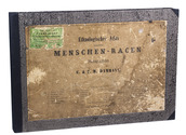
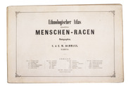
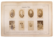
Ethnologischer Atlas sämmtlicher Menschen-Racen in Photographien, . . .
Hamburg, Otto Meissner, [1876]. With letterpress title-leaf and 179 albumen prints mounted on 25 paperboard leaves (31.5×46.5 cm), each leaf with a short general description in German, and all photos with irregularly numbered captions. Loose in a modern black half cloth clamshell box, with the original printed title-wrapper mounted on front. Full description
€ 8,500
Hamburg, Otto Meissner, [1876]. With letterpress title-leaf and 179 albumen prints mounted on 25 paperboard leaves (31.5×46.5 cm), each leaf with a short general description in German, and all photos with irregularly numbered captions. Loose in a modern black half cloth clamshell box, with the original printed title-wrapper mounted on front. Full description