
Inspiration for garden decorating
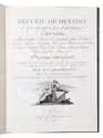
GROHMANN, Johann Gottfried.
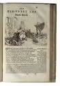
Recueil de dessins d'une execution peu dispendieuse contenans des plans des petites maisons de campagne, petits pavillons de jardins, temples, hermitages, chaumieres, monumens, obélisques, ruines, portails, portes, grilles, bancs des jardins, chaises, volieres, gondoles, ponts, etc. Ouvrage interessant pour cette classe d'amateurs, qui sans faire de grandes dépenses, sont pourtant bien aises d'embellir leurs jardins d'ornemens nouveaux et pleins de goût.
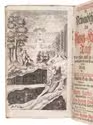
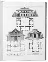
Venice, Joseph Remondini et Fils, 1805. 4to. With an engraved title-page and 37 numbered engraved plates showing numerous designs of maisonettes, pavillions, chapels, bridges, fountains, monuments, temples, gondolas, obelisks, gates, entrances, gazebos, garden-houses, garden-chairs, and tables. 19th-century gold-stamped artificial green leather, marbled paper over boards, blue sprinkled edges. [38] leaves. Full description
€ 2,500
Venice, Joseph Remondini et Fils, 1805. 4to. With an engraved title-page and 37 numbered engraved plates showing numerous designs of maisonettes, pavillions, chapels, bridges, fountains, monuments, temples, gondolas, obelisks, gates, entrances, gazebos, garden-houses, garden-chairs, and tables. 19th-century gold-stamped artificial green leather, marbled paper over boards, blue sprinkled edges. [38] leaves. Full description